

Covering the state of Pennsylvania and other important weather events since 2014. 225K on Facebook, Owner Degreed Meteorologist @denysk02
Pittsburgh, PA
Joined June 2017
- Tweets8.6K
- Following514
- Followers6.9K
- Likes2.8K




NOT AS COLD TONIGHT...
After a few colder nights, it won't be "as cold" tonight as temperatures drop into the 40s, and some spots into the 30s. Locally, colder spots will support frost and perhaps a freeze. It will be a little nice to not wake up to frigid temperatures on Tuesday morning!
#PAwx #Pennsylvania #Frost #Freeze

BRRR... We have another cold morning with many areas in the 30s and some even down in the 20s again! What temperature are you waking up to? Fortunately, we have a decent warmup this afternoon in the mid-upper 60s for many locations under plenty of sunshine. ☀️🥶 #PAwx

Pennsylvania Weather Daily
☀️ Monday, October 19
Good morning, Pennsylvania, happy Monday! We have a BEAUTIFUL start to the workweek with wall-to-wall sunshine and above-average temperatures. High temperatures will climb into the mid-upper 60s this afternoon under mostly sunny skies. This is just some spectacular autumn weather we are having, and we have a generally dry week ahead!
In fact, it is possible that over 70% of the state may not see the next raindrops until NEXT week! Stay tuned for updates!
#PAwx #Pennsylvania #Sunshine #Weather #October


Pennsylvania Weather Daily
☀️ Sunday, October 18
Good morning, Pennsylvania, happy Sunday! We have another cool October day ahead of us as high temperatures climb into the low-upper 50s for most locations. We will also see mostly sunny skies, and it is not expected to be as breezy as it was yesterday. Not "too bad" for a day; it could be worse, and a washout like it was last Sunday! ☀️
Stay tuned for updates & enjoy! #PAwx #Pennsylvania #October #Sunshine #Weather

A very cold night is ahead across Pennsylvania, with temperatures dropping into the upper 20s and lower 30s across much of the state by Sunday morning. For many communities, this will be the coldest night of the fall season so far!
The coldest conditions are expected across northern Pennsylvania, where temperatures could fall into the upper 20s. Areas around Coudersport could drop to 27°, while portions of McKean, Elk, Potter, and Tioga counties may see temperatures between 28° and 31°. Much of western and central Pennsylvania will also see freezing or near-freezing temperatures, generally ranging from 29° to 34°.
**A widespread frost and freeze concern exists across Pennsylvania tonight.** Those with sensitive outdoor plants should take precautions, as temperatures below freezing could damage or kill unprotected vegetation. Bring potted plants indoors and cover sensitive plants where necessary.
Overall, it’ll be a frigid start to Sunday morning across the Commonwealth!
#PAWeatherPlus #PAwx #PennsylvaniaWeather #Pennsylvania #FallWeather

🥶FREEZING NIGHT TONIGHT...
Heads up! Temperatures will drop sharply tonight, and many of us will wake up to frost or even a freeze tomorrow morning. This will be the coldest night in a long time, with areas expected to drop below the freezing mark (pink areas). Localized areas of a hard freeze (sub 28F) are not out of the question, favoring the deepest valleys in the pink zone. Those along the immediate Lake Erie lakeshore and across the Philadelphia region will be warmer, but I would still take action in moving/covering plants in case of locally cold pockets that can support frost.
🪴If you have tender plants or garden vegetables outside, now is the time to cover them or bring them in. It’s also a good idea to disconnect and drain your outdoor hoses and make sure any outdoor pets have a warm place to stay. 🐶😺
#PAwx #Frost #Freeze #PennsylvaniaWeather

❄️ Wow, it is quite chilly out there this morning! The radar is detecting snow in some of these showers across north-central Pennsylvania, primarily north of I-80. Are you seeing any snow flurries or snow pellets? #PAwx #Snow #Pennsylvania

Pennsylvania Weather Daily
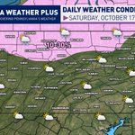
⛅ Saturday, October 17
Good morning, Pennsylvania, happy Saturday! We have a MUCH colder day ahead of us, as yesterday's strong cold front ushered in the coldest air mass since April. High temperatures will range from the mid 40s to mid 50s this afternoon, and it will feel as much as 4-8 degrees colder with the gusty winds. Expect wind gusts of 20 - 30 mph out of the northwest through the afternoon.
➡️A few mixed snow pellet/rain showers are possible this morning across northern Pennsylvania. No accumulations are expected, and the risk remains at 10-30%, so it will be hit-or-miss!
Stay tuned for updates & have a great Saturday! It's chilly, but at least it is dry! #PAwx #Pennsylvania #Weather #October #Saturday


⛈️STORMS ➡️ SNOW SHOWERS❄️
The reason for the strong thunderstorm risk today is a strong cold front that will pass through this evening and tonight! In fact, temperatures will drop as much as 25 - 30 degrees within a 24-hour time span, cold enough to bring some lake-effect snow showers along and north of I-80 Saturday morning in Pennsylvania.
➡️Absolutely NO accumulation is expected due to the warm ground. These will be scattered in nature, so NOT everyone north of I-80 will see snow flurries or snow pellets. You will have to get under one of these showers to see it. Just don't be surprised if you see some "white stuff" in the sky tomorrow morning!
Are you ready for winter? #PAwx #Pennsylvania #Snow

⚠️ ⛈️: A strong October cold front will help to develop a line of stronger thunderstorms that will move through Pennsylvania and other portions of the Northeast this Friday afternoon and evening. Expect wind gusts 40 to 55 mph some lightning and heavy downpours. The tornado risk is near 0%. If you have outdoor plans, be prepared to take shelter, but this line will last 30 to 60 minutes, so cancellations aren’t necessary. Stay tuned and follow for more updates!
#PAwx #Pennsylvania #SevereWeather #Meteorology
⚠️ TRACKING OUT TODAY'S STORMS ⚠️
The abnormal October warmth and humidity, combined with an October-like cold front, will allow for a line of gusty to strong storms to develop and impact central and eastern Pennsylvania this afternoon and evening. The squall line will develop in central Pennsylvania between 2 - 3 PM and track eastward into the evening. The dotted lines are the current approximation for this line of storms, +/- 1.5 hours.
This line will be quick-hitting, but bring isolated threats of lightning strikes and gusty winds of 45 to 55 mph. The more sun this afternoon, the higher the instability, which will help to increase the wind gust potential.
⚠️ OUTDOOR PLANS/FRIDAY NIGHT FOOTBALL? I would not cancel these plans. This squall line will be relatively short-lived, lasting 30 - 60 minutes at any given location. Take proper precautions when this line moves through. Behind this squall, be prepared for dropping temperatures, breezy winds, and perhaps a light, brief shower.
Behind this front, MUCH colder air filters in. Some areas may go from storms to flurries early tomorrow morning! #PAwx #Pennsylvania #Thunderstorm #October

⚠️⛈️ FRIDAY SEVERE WEATHER UPDATE...
The active 2026 severe weather season does not want to leave us! An incoming strong cold front will spark a line of strong thunderstorms this afternoon and evening. This is due to the above-average temperatures and higher humidity levels, which will provide "storm fuel" for these storms to develop. The strength of this cold front will help to develop a line of strong showers and storms that will quickly sweep west-to-east, bringing strong wind gusts and the potential for some low-end wind damage.
⚠️ OUTDOOR PLANS/FRIDAY NIGHT FOOTBALL? I would not cancel these plans. This squall line will be relatively short-lived, lasting 30 - 60 minutes at any given location. Take proper precautions when this line moves through. Behind this squall, be prepared for dropping temperatures, breezy winds, and perhaps a light, brief shower.
ZONE 2: This is where the strongest part of the squall will be, due to the overlap of the strongest wind shear & instability. Scattered strong wind gusts of 45 - 55 MPH expected, with isolated gusts up to 60 MPH possible. Strong wind gusts may lead to some tree damage and a few power outages. Make sure to tie down any holiday lawn decorations, trash cans, and furniture. The tornado risk is near 0% personally. I've also seen posts calling for "destructive winds", which will NOT happen. Destructive winds are classified as 80+ MPH by the NWS.
ZONE 1: Isolated strong wind gusts of 40 - 50 MPH expected; minimal risk for gusts over 50 mph. Areas that see strong wind gusts should expect a few downed limbs/branches and expect some furniture/decorations to be blown around. The squall will be in the "weaker" stages within this zone. The tornado risk is near 0% personally.
-> Keep in mind, severe weather does not impact every house or neighborhood. Unless it is a large outbreak, severe weather impacts will differ even across small areas. It is always good to be prepared by having multiple ways of receiving severe weather alerts and a shelter to take cover in when severe weather strikes. <-
⚠️Stay tuned for updates! Make sure you have a way to receive severe weather alerts and have an indoor shelter to take cover in during a storm this afternoon and evening! Expect more updates to come on this developing severe weather threat.
#PAwx #Pennsylvania #SevereWeather #Meteorology #Thunderstorm

Pennsylvania Weather Daily
🌩️ Friday, October 16
MAIN HEADLINES: A strong cold front pushes into the state today, sparking showers and thunderstorms.
Good morning, Pennsylvania, happy Friday! We've made it to the big cold front day, when rain and thunderstorms will be quite likely across the state. While the graphic looks wet, keep in mind it won't be raining the entire day. Areas across central/eastern PA will get several hours of sunshine in the early-to-mid afternoon, before the cold front moves through. Western PA will see a bit more rain and less sunshine. High temperatures will range from the low 60s in northwestern PA to the low-mid 80s across south-central and southeastern Pennsylvania, which will be dependent on your proximity to the cold front! ⚠️ Strong thunderstorms will be possible today; an update will be posted shortly.
🌧️ Today's rain percentage represents the chance of rain or storms at any time today. Most locations will see some rain today, so when you head out the door, it will be wise to grab your umbrella and rain jacket!
#PAwx #Pennsylvania #October #Thunderstorm #Weather


** FRIDAY STRONG STORM RISK **
An incoming strong cold front will move into the region Friday afternoon and evening. Ahead of this cold front, temperatures and humidity levels will rise to unseasonable levels (air temps 75 - 80+), (dew points 64 - 69), allowing for increasing levels of instability. The strength of this cold front will help to develop a line of strong showers and storms that will quickly sweep west-to-east, bringing strong wind gusts and the potential for wind damage. Despite the calendar reading mid-October, the 2026 severe season just cannot let go! ⛈️⛈️⛈️
AREA A: This is where the strongest part of the squall will be, due to the overlap of the strongest wind shear & instability. Scattered strong wind gusts of 45 - 55 MPH expected, isolated gusts up to 60 or greater possible. Strong wind gusts may lead to some tree damage and a few power outages. Make sure to tie down any holiday lawn decorations, trash cans, and furniture.
AREA B: Isolated strong wind gusts of 40 - 50 MPH expected; minimal risk for gusts over 50 mph. Areas that see strong wind gusts should expect a few downed limbs/branches and expect some furniture/decorations to be blown around. The squall will be in the "weaker" stages within this zone.
-> Keep in mind, severe weather does not impact every house or neighborhood. Unless it is a large outbreak, severe weather impacts will differ even across small areas. It is always good to be prepared by having multiple ways of receiving severe weather alerts and a shelter to take cover in when severe weather strikes. <-
⚠️Stay tuned for updates! Make sure you have a way to receive severe weather alerts and have an indoor shelter to take cover in during a storm Friday afternoon and evening! Expect more updates to come on this developing severe weather threat.
#PAwx #Pennsylvania #SevereWeather #Thunderstorm

⚠️GUSTY FRIDAY THUNDERSTORMS ⚠️
The abnormal October warmth and humidity, combined with an October-like cold front, will allow for a line of gusty to strong storms to develop and impact central and eastern Pennsylvania Friday afternoon and evening. The squall line will develop in central Pennsylvania between 2 - 3 PM and track eastward into the evening. The yellow dotted lines are the current approximation for this cold front, +/- 1.5 hours.
This line will be quick-hitting, but bring isolated threats of lightning strikes and gusty winds of 45 to 55 mph. The more sun tomorrow, the higher the instability, which will help to increase the wind gust potential. I don't foresee this being too crazy, but it will be something you notice come through!
Behind this front, MUCH colder air filters in. Some areas may go from storms to flurries! #PAwx #Pennsylvania #Thunderstorm #October

ONE MORE HOT DAY TOMORROW...
Ahead of the cold front tomorrow, temperatures will spike, and dew points will rise into the "uncomfortable" 65 - 70 degree range, giving us one more taste of summer. High temperatures look to be in the 70s to low 80s for many locations tomorrow. This will help to fuel a line of stronger thunderstorms during the afternoon and evening hours, which will come along the cold front.
BIG CHANGES COMING: ENJOY it (or not). High temperatures on Saturday drop into the 40s and 50s. Wind chills will be in the 30s and 40s. Snow flurries remain a possibility Friday night into Saturday morning north of I-80. A widespread frost/freeze is likely Saturday night into Sunday morning.
Stay tuned for updates! #PAwx #Pennsylvania #October #Warmth

Pennsylvania Weather Daily
⛅ Thursday, October 15
MAIN HEADLINES: Turning (briefly) seasonable as our next system begins to approach from the south.
Good morning, Pennsylvania, happy Thursday! We are *almost* at the end of the week, and we have some nicer weather for portions of the state. A cold front moved through overnight, which has ushered in some *much* cooler air, which is more "normal" for mid-October. High temperatures will range from the low to upper 60s. However, we do have a disturbance that will begin to rise out of WV/MD, which will allow for some spotty to scattered showers to develop across southern PA, especially later into the afternoon.
🌧️ Today's rain percentage represents the chance of rain through this morning and afternoon. Not every single location will see rain, but the higher the percentage, the greater your risk of seeing some rain.
Stay tuned for updates! #PAwx #Pennsylvania #Rain #October #Weather


Argubaly is one of the best seasons of the year here in Pennsylvania: fall foliage season! The stretch of cooler weather last week helped to speed up the leaf-changing process, but lately the warmth and humidity may have stunted the progress. Regardless, high color is being reported across north-central Pennsylvania and across portions of the Pocono Mountains.
🍂🍁What is the foliage situation in your area? Feel free to share any photos!
#PAwx #Pennsylvania #FallFoliage #Fall #Autumn

FROST/FREEZE LIKELY SATURDAY NIGHT...
Heads up! Temperatures will drop sharply Saturday night, and many of us will wake up to frost or even a freeze on Sunday morning. This will be the coldest night in a long time, with areas expected to drop below the freezing mark.
The coldest air will settle across northern and central Pennsylvania, where a freeze is favored with lows in the upper 20s to low 30s. That includes the Northern Tier, Williamsport, State College, Scranton, and Wilkes-Barre. Most of southern and western PA, including Pittsburgh, Harrisburg, Lancaster, Reading, and the Lehigh Valley, is looking at frost, with temperatures in the 33 to 36-degree range. Philadelphia and the southeast will stay milder, in the upper 30s to low 40s, so frost is much less likely there.
If you have tender plants or garden vegetables outside, now is the time to cover them or bring them in. It’s also a good idea to disconnect and drain your outdoor hoses and make sure any outdoor pets have a warm place to stay.
#PAwx #Frost #Freeze #PennsylvaniaWeather

WATCHING FOR GUSTY SHOWERS/STORMS...🌩️
We've had some summer-like temperatures this week, but what about summer-like thunderstorms? A strong cold front will move through the region Friday afternoon and evening, and the latest model guidance is picking up on a potential gusty line of storms. Ahead of the cold front, temperatures will rise once again in the mid-upper 70s with dew points in the mid-60s, allowing some fuel to build for storms. The stronger forcing of this cold front will help to aid in the potential for gusty winds.
❄️Behind this cold front, temperatures will *plummet*, and we will see rain showers change over to a few snow showers across far northern Pennsylvania. High temperatures on Saturday? Ranging from the upper 30s (northern PA) to lower 50s (southern PA). This will be our biggest chill since April!
#PAwx #Pennsylvania #ColdFront #Weather #October
