

We manufacture & supply real-time systems for environmental observations
Rijswijk, Nederland
Joined April 2019
- Tweets112
- Following283
- Followers117
- Likes11




Wave height and sea surface temperature, measured in real time and streamed straight to your browser. Meet the OBS-Buoy 400.
A self-contained wave buoy that just gets on with it:
▸ Battery-powered, no mains or shore power needed
▸ Live to the Obscape Data Portal, view, chart and download from anywhere
▸ Built for the conditions it sits in, salt, sun and swell
▸ Field-proven on deployments around the world
Reliable wave monitoring for ports, coastal management, marine construction and environmental work.
#WaveData #WaveBuoy #MetOcean #CoastalMonitoring #EnvironmentalMonitoring #OceanTech
Out in the field, a sensor is only as good as the box keeping it alive and online.
Every gauge, camera, weather or water-quality station you put in the field needs two things to earn its keep: power, and a way to get its data home. That's the whole job of the PTM, our Power & Telemetry Module.
- Solar and battery: deploy once, run for years, no mains, no site visits
- Cellular telemetry, with optional satellite: data home no matter where the device is located
- Can even turn a standard navigation buoy into a smart, data-gathering one
Not the part you notice. The part you can't do without.
#Telemetry #RemoteMonitoring #OffGrid #EnvironmentalMonitoring #IoT #OceanTech

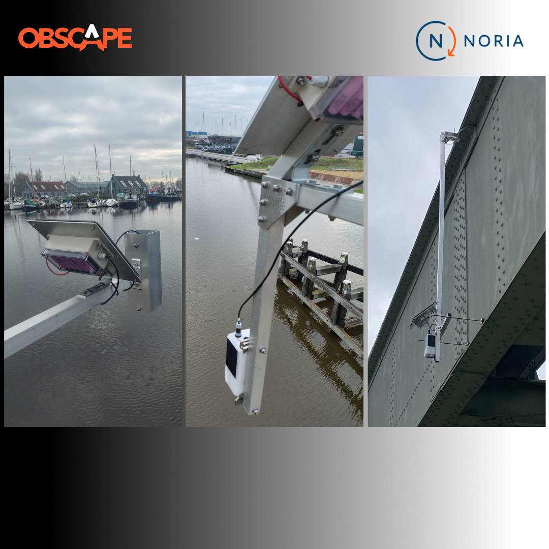
Cleaning up our waterways takes more than one clever idea. It takes people who understand the problem, and tools you can trust in the field.
That is what brought Obscape and Noria | Urban Plastic Soup Solutions together, a Delft-based company tackling urban "plastic soup," the floating litter clogging our city waterways. Their approach: Research, Remove, Reduce.
Read the full story: site.obscape.com/cleaning-up…
#PlasticSoup #PlasticPollution #EnvironmentalMonitoring #CleanRivers #WaterQuality

It doesn't always go to plan.
We are scientists and engineers. We build wave buoys, weather and water quality stations, cameras, and the telemetry that gets the data home. Making slick videos about it is not quite what we trained for.
Turns out, getting the take right can be harder than getting the tech right. Rugged kit. Slightly less rugged humans.
#EnvironmentalMonitoring #OceanTech #BehindTheScenes #TeamCulture #Engineering #MetOcean
A site survey tells you exactly what conditions were like — on the day of the survey.
The problem is what happens between site surveys. The storm surge, the flood peak, the turbidity spike after heavy rain, the pre-dawn oxygen crash — the events that actually drive decisions rarely land on a survey date.
Continuous monitoring fills those gaps:
- You see the event as it happens, not weeks later in a report
- Threshold alerts flag the moment something crosses a limit
- You build a real baseline — what's normal for this site, so the abnormal stands out
- Every reading is comparable across seasons and storms
Site surveys still have their place. But when the environment changes fast, the record that matters is the continuous one.
#EnvironmentalMonitoring #RealTimeData #CoastalMonitoring #MetOcean #Hydrology #WaterQuality #Hydrography

Tech Tip with Shawn: no cell network on the SIM
Setting up your new device but you get an error ...no cell network on the SIM
In this Tech Tip, Shawn walks through the easy troubleshooting steps.
For more Tech Talks with Shawn YouTube: youtu.be/f5AZ-_y0myc
#EnvironmentalMonitoring #RemoteMonitoring #Telemetry #FieldTips #IoT #TechTip
Blog alert: One login. Every site. No subscription.
If you run environmental monitoring, you know the usual story: one platform for the buoys, another for the weather station, a separate export for the water-quality data, and a monthly bill for each. Your data ends up scattered, and half of it lives on someone else's meter.
The Obscape Data Portal works differently. Every device we make streams to one place, so you get:
▸ Buoys, weather stations, water-quality sondes, cameras and level gauges, all on a single screen
▸ Threshold alerts the moment a reading crosses a limit, so you see it coming, not after
▸ Full history beside live data, and direct API access as standard
▸ A live view you can share with a colleague, client or regulator in seconds
And the part people don't expect: there's no subscription. We're a hardware company, so the portal comes with the kit. No per-seat fees, no annual licence. Your data stays yours.
It's sensor-agnostic too, so it works with the instruments you may already own.
We wrote about how it all fits together, and why it's built this way, on Obscape Insights:
site.obscape.com/one-portal-…
#EnvironmentalMonitoring #DataPortal #RemoteMonitoring #MetOcean #Hydrology

A number tells you the water level. It doesn't tell you why it moved.
Pairing a radar level gauge and a time-lapse camera is a great way to understand the data. Now every reading comes with a matching image: you can check your site remotely and see what's driving the spikes. It's more than just a figure on a screen.
Read our latest blog on Obscape Insights: lnkd.in/dBWWYE-u
Measure it, and see it.
#WaterLevelMonitoring #RadarLevelGauge #TimeLapseCamera #Hydrology #FloodMonitoring
You can't protect what you don't understand.
Today is Marine Protected Areas Day — a global moment to recognise the stretches of ocean we set aside to protect, and the life that depends on them.
But an MPA is only as good as our understanding of it. Protection works when we can actually see what's happening beneath the surface — water temperature and quality, waves and currents, turbidity, and the slow changes a single survey would miss. You can't manage a marine environment you can't see, and you can't prove protection is working without a baseline to measure against.
That's the part we care about: giving the people who look after these places the real-time data to do it well.
Here's to everyone protecting our oceans — and to the goal of 30% protected by 2030. 🌍
#MPADay #MarineProtectedAreas #OceanConservation #30x30 #EnvironmentalMonitoring #OceanDecade

Built for real world monitoring
Coasts, harbours, rivers, dams, offshore — the readings that drive real decisions rarely come from somewhere convenient. So that's where our kit goes.
▸ Solar-powered and off-grid — no mains, no cabinet, no monthly site visit
▸ Cellular telemetry, satellite — get your data from anywhere
▸ Streaming live to the Obscape Data Portal — thresholds, alerts, full history
▸ Built for harsh environments — salt, spray, sun and swell, season after season
Because a monitoring network only earns its keep when the data keeps arriving — especially when conditions are at their worst.
Real conditions. Real-time data.
Wherever your site is, we can help you measure it — and make the data usable.
#EnvironmentalMonitoring #CoastalMonitoring #WaterLevel #MetOcean #RemoteMonitoring #Telemetry


Just got an OBS-Buoy 7 Watt (or weighing one up)?
This short, no-nonsense quick-start takes you from box to buoy-in-the-water in about three minutes:
▸ Register and couple your device on the Obscape Data Portal
▸ Fit the SIM and battery, and power up
▸ Confirm it's posting data before you deploy
Simple to set up, quick to deploy — and easy to get right the first time.
#WaveBuoy #WaveMonitoring #MetOcean #Oceanography #EnvironmentalMonitoring #CoastalEngineering
Dredging near sensitive water?
Your permit probably requires real-time turbidity monitoring — with a stop-work the moment you breach a threshold.
We've packaged the kit that keeps you compliant and working — Level, waves, turbidity and a live visual record, all on one Data Portal with threshold alerts before you hit the limit. Solar-powered, deploy in days.
Special pricing runs until 31 August — see the packs and get a quote for your site:
lnkd.in/ebU6x6rN
hashtag#Dredging hashtag#Turbidity hashtag#EnvironmentalMonitoring hashtag#CoastalEngineering hashtag#MetOcean

Vlora Bay, Albania — now reporting in real time.
Together with our long-time partner B.V.S. Consult, a complete coastal monitoring network went into the water across Vlora Bay and the Zvernec Lagoon:
- An OBS-Buoy 400 measuring waves and sea surface temperature in the bay
- A buoy-mounted ADCP, streaming current profiles through the water column
- Water level stations at the lagoon and its inlet
All data collated in the Obscape Data Portal — live graphs, threshold alerts — so conditions in the bay can be read from anywhere, the moment they change.
The work with Boyan Savov and the B.V.S. Consult team goes back to the first HERMES wave buoy deployments on the Bulgarian and Albanian coasts in 2019 — the kind of partnership that turns instruments into decisions.
#EnvironmentalMonitoring #WaveData #CoastalEngineering #Adriatic #OceanTech #MetOcean #Hydrology


Wave data, explained: what is Hm0? If you've looked at wave data, you've seen "Hm0" — but what does it actually mean? Hm0 is the significant wave height, calculated from the wave energy spectrum. In practice it's very close to the average height of the highest one-third of waves — and it's the figure most coastal and offshore decisions are built on. Why it matters: a single "wave height" hides a lot. Hm0 gives a consistent, statistically robust number you can compare across time, sites and storms — so a 3 m Hm0 today means the same as a 3 m Hm0 last winter. Want the rest of the wave parameters demystified? We broke them all down: site.obscape.com/understandi… #WaveData #Oceanography #CoastalEngineering #MetOcean #EnvironmentalMonitoring

A single storm can redraw a coastline — a time-lapse camera lets you watch it happen.
The Obscape F12 MP Time-Lapse Camera captures a clear visual record of how a site changes over time: erosion, sediment movement, dune recovery, a construction site, a river mouth.
Key specs:
• 12-megapixel sensor, sharp from 5 cm to infinity
• Capture intervals from 10 to 60 minutes
• Solar-powered with cellular data transfer — deploy it and leave it
• Download your sequence as JPEGs, or straight to MP4 video
• 66–102° field of view
Pair it with your wave, tide or water-level data and you've got the numbers and the picture, side by side.
#CoastalMonitoring #TimeLapse #Erosion #EnvironmentalMonitoring #OceanTech

Real-time water quality monitoring, built around the sensor you already trust.
Instead of locking you into a fixed parameter set, the Water Quality Station is a complete, deployable platform that integrates your choice of industry-standard multiparameter sonde — In-Situ Aqua TROLL, YSI EXO, NKE WiMo, Aqualabo and more.
What you get:
• Solar-powered, runs unattended
• Cellular telemetry (satellite option available)
• Live data to the Obscape Data Portal — free for the life of the station
• Your sonde, your parameters: turbidity, dissolved oxygen, pH, salinity, temperature… whatever the application needs
From rivers and estuaries to coastlines and aquaculture — one station, your sensors, data you can act on.
hashtag#WaterQuality hashtag#EnvironmentalMonitoring hashtag#RealTimeData hashtag#Rivers hashtag#OceanTech

Why does a wave buoy need a special mooring?
Because a wave buoy measures waves by moving with them — riding the circular orbit of the water at the surface. Tie it down with an ordinary straight mooring and every time the line snaps tight it yanks the buoy off that path. The result: underestimated wave heights, biased directions, and a dataset you can't fully trust.
Our fix is the concertina mooring — in-line floats, an in-line weight and an anchor float, sized to each site, that expand and contract with every wave so no tension ever reaches the buoy. The buoy stays free, the data stays clean.
Full walkthrough on Obscape Insights: site.obscape.com/why-wave-bu…
Or watch the explanation video: youtu.be/2McISSJCOfk
#WaveData #OceanTech #CoastalEngineering #Metocean #EnvironmentalMonitoring #WaveBuoy #Mooring
Bringing real-time data to remote corners of the world.
Great to see an Obscape Radar Level Gauge deployed for monitoring water levels in a highly remote area near Santa Marta, Colombia.
Managing vital water resources in isolated regions presents massive operational hurdles. Traditional cellular networks often fall short, and sending teams out for manual readings is both costly and impractical.
With the satellite functionality on our Radar Level Gauge, highly precise, real-time hydrological data directly from the field can be used for decision making.
- True global connectivity — integrated satellite telemetry streams data reliably from any location on Earth.
- 100% self-sustaining — powered entirely by built-in solar panels and an internal battery; no mains power required.
- Zero water contact — mounted above the surface, eliminating biofouling, sediment build-up and debris damage.
- Instant data access — feeds straight into the Obscape Data Portal for continuous tracking, reporting and threshold alerts.
Thanks for trusting Obscape tin the mission for sustainable water governance and ecosystem protection — and to our Colombian distributor Enviteck for bringing this solution to life.
#WaterResourceManagement #EnvironmentalMonitoring #Hydrology #SatelliteTelemetry #RemoteSensing #Sustainability #SantaMarta


How much pressure can a 2 kg data logger handle? A lot more than you'd expect. We put our Obscape PTM (Portable Telemetry Module) to the test in a hydraulic press. The pressure kept increasing...5 tonnes. 10 tonnes. 15 tonnes. ...until it reached an incredible 17 tonnes of crushing force. Why? Because environmental monitoring equipment doesn't have an easy life. It faces rough handling, harsh weather, impacts, and demanding deployments. That's why we engineer our hardware to keep delivering reliable data when conditions are anything but ideal. Watch the video to see how the PTM performs under extreme pressure. Our data logger can handle 17 tonnes of pressure. Can yours? #EnvironmentalMonitoring #Engineering #FieldTesting #BuiltToLast #MarineTechnology #DataLogging #RuggedDesign
We've started a blog — a place to go behind the scenes of real-time environmental monitoring. No sales fluff, just clear writing from the people who design and build the systems.
First articles up now:
• Understanding Wave Data — what Hm0, Tp and every parameter actually mean
• How Ocean Wave Monitoring Works
• Pressure vs Radar? — how water level measurement works
• Why real-time environmental data matters
• Smarter offshore operations with real-time data
Have a read: site.obscape.com/obscape-ins…
We'll keep adding to it — what would you like us to explain next?
#EnvironmentalMonitoring #OceanData #WaveData #CoastalEngineering #OceanTech
