

Official Twitter account for the National Weather Service Abilene/San Angelo. Details: https://xitter.cf/t.co/rGKCWIZoUO
- Tweets24.3K
- Following255
- Followers23.5K
- Likes2K







ALT Graphic showing highs and lows for select cities across the area through next weekend.

ALT Graphic showing forecast lows across west central Texas tonight. Text box on the left discussing frost potential for river valleys and low lying areas.

ALT Graphic shows forecast high temperatures for this afternoon.

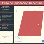
ALT Este gráfico muestra la localización en el mapa de un aviso de inundación repentina. El aviso estará en efecto hasta las 7:00 PM CDT. El aviso incluye a Taylor County, TX. El aviso incluye el sureste del condado de Nolan en el oeste centro de Texas y el suroeste del condado de Taylor en el oeste centro de Texas. ¡Evite caminar o manejar su vehículo a través de áreas inundadas! ¡Muévase a un terreno más alto inmediatamente! Hay 794 personas bajo este aviso incluyendo 0 escuelas y 0 hospitales.

ALT This graphic displays a flash flood warning plotted on a map. The warning is in effect until 7:00 PM CDT. The warning includes Nolan County, TX, Taylor County, TX. This warning is for Southeastern Nolan County in west central Texas and Southwestern Taylor County in west central Texas. Avoid walking or driving through flood waters! Move immediately to higher ground! There are 794 people in the warning along with 0 schools and 0 hospitals.

ALT Graphic on the left shows the Excessive Rainfall Outlook for today and tonight, and icons and text on the right side have additional information on the heavy rain and flash flooding threat.

ALT Este gráfico muestra la localización en el mapa de un aviso de tormenta severa. El aviso estará en efecto hasta las 8:30 PM CDT. El aviso incluye a Haskell TX, Throckmorton TX, Woodson TX. El aviso incluye el condado de Haskell en el oeste centro de Texas y el condado de Throckmorton en el oeste centro de Texas. Las amenazas asociadas a este aviso son: ráfagas de viento de 60 MPH y granizo del tamaño de una pequeña canica. Hay 5,210 personas bajo este aviso incluyendo 7 escuelas y 2 hospitales.

ALT This graphic displays a severe thunderstorm warning plotted on a map. The warning is in effect until 8:30 PM CDT. The warning includes Haskell TX, Throckmorton TX and Woodson TX. This warning is for Haskell County in west central Texas and Throckmorton County in west central Texas. The threats associated with this warning are wind gusts up to 60 MPH and pea sized hail. There are 5,210 people in the warning along with 7 schools and 2 hospitals.

ALT Graphic showing an image of a Severe Thunderstorm Watch on the right, with a text description of the possible conditions.

ALT Este gráfico muestra la localización en el mapa de un Vigilancia de Tormenta Severa número 685. El aviso estará en efecto hasta las 11:00 PM CDT.Las amenazas asociadas a este aviso son. Varios tornados posibles. Granizo disperso de hasta limon posible. Ráfagas Dispersas de Hasta 75 MPH Posibles. Hay 1,180,572 personas bajo este aviso incluyendo 644 escuelas y 70 hospitales.

ALT This graphic displays Severe Thunderstorm watch number 685 plotted on a map. The watch is in effect until 11:00 PM CDT. The watch includes parts of Oklahoma and Texas. The threats associated with this watch are a couple tornadoes possible, scattered hail up to two inch size possible and scattered gusts up to 75 mph possible. There are 1,180,572 people in the watch along with 644 schools and 70 hospitals.

ALT Graphic on the right shows a map where a Flash Flood Watch is in effect from Thursday, October 15th at 1 PM through Friday, October 16th, 7 AM. On the left is a text description of what is expected and when.