

Official Twitter feed of Old Dominion University Emergency Management. To report an emergency, contact ODU Police by dialing 757-683-4000.
- Tweets1K
- Following226
- Followers1.1K
- Likes699






ALT Take action today. Determine your risk from water and wind. Begin preparing now, before a storm. Learn how to understand hurricane forecasts and alerts. Learn what to do before, during, and after a storm.


ALT Strengthen you home. Keep trees around your home trimmed. Have the proper material in advance to board up your windows. Bring loose outdoor items inside. Secure all loose doors. Move your car inside if you can.

ALT Use Caution After Storms. If you evacuated, only return home when directed it's safe to do so.. Remain vigilant, as hazards remain: heat, downed powerlines, floodwaters and more. Clean up safely: don't push yourself, and check on your neighbors. Only use generators outdoors, 20+ ft from your home. Prepare for the likelihood that help and communications may not be available.

ALT NWS Wakefield post regarding Free SKYWARN weather training classes that are upcoming over the next few weeks.

ALT Tropical tornadoes. Did you know that they can spin up quickly and are often short-lived, form within the outer rainbands away from the center, are most likely on the front-right side of the storm, are not usually accompanied by hail or a lot of lightning, and can develop during the day or night.

ALT Stay protected during storms. Stay in your safe places from water and wind. Have a way to get weather alerts and forecast updates. Keep in mind that impacts can be felt far from the coast. Listen to local officials and avoid travel unless ordered to evacuate.

ALT Hurricane Hazard Risks. 1) Storm surge is water pushed onshore by the tropical system. It causes the most damage of any hazard. 2) Wind can top 200mph and cause massive damage to buildings and trees. 3) inland flooding caused by heavy rain damages homes and can wash out roadways well away from the coast. 4) tornadoes are common in tropical systems. 5) rip currents and rough seas are common both before and after a hurricane.

ALT Inland Flooding. Image depicts a cartoon road with cars on it, covered with flooding from heavy rain. It doesn't take a major hurricane to cause major impacts to an area. Even relatively weak tropical systems can produce vast amounts of rainfall well inland from the coast.

ALT Don't underestimate the power of water. 6 inches of fast-moving water can knock over and carry away an adult. 12 inches of fast-moving water can carry away a small car. 18-24 inches of fast-moving water can carry away most large SUVs vans and trucks.

ALT Get moving when a storm threatens. Protect your home, cover your windows and secure doors and loose items. Determine sheltering options and consider your pets. Ready your go-bag, meds, and supplies, charge phone, and fill up/charge vehicle. Help your neighbors, especially the elderly and other vulnerable people. Follow evacuation orders if given.

ALT Plan for your pets. Not all shelters accept pets. Plan in advance so your pets are taken care of. Visit ready.gov/animals

ALT Strengthen you home. Keep trees around your home trimmed. Have the proper material in advance to board up your windows. Bring loose outdoor items inside. Secure all loose doors. Move your car inside if you can.

ALT When the wind blows. Image of a population center on a 3D map. Identify an interior room in your house or at work that you can take shelter in during high wind warnings. If you are driving and aren't near a sturdy building, hold the steering wheel with both hands and slow down. Keep a distance from high profile vehicles. High winds can create dangerous fallen or blowing objects.

ALT Image showing the Saffir Simpson Hurricane Wind Scale from Category 1 to 5. Cat 1: Wind 74-95mph with very dangerous winds producing some damage. Cat 3: wind 111-129mph with devasting damage occurring. Cat 5: wind 157mph or higher with catastrophic damage occurring.

ALT Graphic on the right shows a NHC forecast cone track displayed on a mobile phone. Understand forecast information: Rely on forecasts from the NHC and your local NWS office. Know your alerts and the difference between a Watch and Warning. Focus on potential impacts, regardless of size or category. Know that deadly hazards occur well outside of the forecast cone.

ALT 5 things to know about where to get hurricane info. 1) Television - tune into your trusted local news source. 2) Phone - access mobile.weather.gov on your phone and get Wireless Emergency Alerts. 3) Radio - receive forecast information and news on your NOAA Weather Radio. 4) Social media - stay in touch with friends and family and receive updates from your trusted sources. 5) Computer- access information from weather.gov, ready.gov, and flash.org.

ALT Image on the right of flooded homes and land. Title is Know Your Risk: Water and Wind. Bullet points include: consider your threats: storm surge, heavy rain flooding, strong winds, tornadoes, rip currents. Determine if you live in a flood-prone area. Find out if you live in an evacuation zone. Identify your home's structural risks (mobile homes and basements can be especially vulnerable).

ALT Hurricane hazard risks: Storm surge, wind, inland flooding, tornadoes, and rip currents.

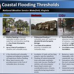
ALT Understanding storm surge flooding. NOAA coastal flooding forecasts are expressed as feet above ground level. The image depicts the difference between a nice weather day with the normal high tide being far from shore. Versus storm surge inundating normally dry ground well above the normal high tide levels.

ALT Potential Storm Surge Flooding. The NWS' potential storm surge flooding map indicates the height above ground that the water could reach. The image in the center depicts the varying levels of storm surge expected around the coastline. From Minor to Major.

ALT An evacuation plan. Find out if you would need evacuate. Plan your route and have an alternate route in case its blocked. Leave when ordered to do so, don't wait. Communicate your plan with someone outside the storm path. Plan for your pets too!!

ALT NWS Wakefield post regarding Free SKYWARN weather training classes that are upcoming over the next few weeks.

ALT Prepare before hurricane season. Develop an evacuation plan. Assemble disaster supplies food water batteries charger radio and csh. Get an insurance check up and document your possessions. Create a communication plan with hand-wrriten list of contacts. Strengthen you home.

ALT Updating your insurance. Check your policies well ahead of the storm. Make sure you have flood insurance. Visit floodsmart.gov to learn about your flood risk. Prepare your home and vehicles. Know where your documents are located, take them with you if you evacuate.

ALT Strengthen you home. Keep trees around your home trimmed. Have the proper material in advance to board up your windows. Bring loose outdoor items inside. Secure all loose doors. Move your car inside if you can.

ALT Cell phone notification with an important notice shown: Virginia's statewide tornado drill will be held on March 10th at 945am. Practice your tornado safety plan!
