

Meteorologist @wusa9 I like Weather, News, Football, Baking & Fashion. Links & RTs aren't endorsements. Opinions are my own.
- Tweets22.4K
- Following1.1K
- Followers6.2K
- Likes33.2K



ALT Thunderstorm Watch: A Severe Thunderstorm Watch is issued when severe storms are possible. Stay tuned to forecast updates and monitor sky conditions. Know where to take shelter. Thunderstorm Warning: A Severe Thunderstorm Warning is issued when a severe storm is happening or imminent. Take shelter immediately! Check for forecast updates.

ALT A weather alert map from the National Weather Service Baltimore/Washington office issued on July 6, 2026, at 5:47 AM EDT. The graphic highlights areas under a Flood Watch for flash flooding, valid from 4 PM until midnight across the local area. The map uses green shading to denote counties and cities included in the Flood Watch, covering much of central and northern Virginia, central and western Maryland, and parts of the West Virginia panhandle. Major cities and towns highlighted in green within the watch area include Washington D.C., Baltimore, Fredericksburg, Charlottesville, Harrisonburg, Winchester, Leesburg, Warrenton, Martinsburg, and Hagerstown. Areas to the far west (including Cumberland, Oakland, and Franklin) and to the far east (such as Lexington Park and Elkton) are shaded dark gray, indicating they are outside the watch zone. Major interstate routes (I-95, I-81, I-64, I-66, and I-70) are marked across the region in red.

ALT This graphic displays Severe Thunderstorm watch number 465 plotted on a map. The watch is in effect until 1:00 AM EDT. The watch includes parts of Delaware, District of Columbia, Maryland, New Jersey, Pennsylvania, Virginia and West Virginia. The threats associated with this watch are no tornadoes expected, isolated hail up to quarter size possible and scattered gusts up to 65 mph possible. There are 19,996,765 people in the watch along with 4802 schools and 291 hospitals.

ALT This graphic illustrates temperature records from around the region.


ALT This graphic displays Severe Thunderstorm watch number 457 plotted on a map. The watch is in effect until 10:00 PM EDT. The watch includes parts of District of Columbia, Maryland, Virginia and West Virginia. The threats associated with this watch are no tornadoes expected, isolated hail up to quarter size possible and scattered gusts up to 75 mph likely. There are 13,913,334 people in the watch along with 3575 schools and 193 hospitals.


ALT This graphic displays Severe Thunderstorm watch number 375 plotted on a map. The watch is in effect until 9:00 PM EDT. The watch includes parts of Delaware, District of Columbia, Maryland, New Jersey, Pennsylvania, Virginia and West Virginia. The threats associated with this watch are a couple tornadoes possible, isolated hail up to quarter size possible and scattered gusts up to 70 mph likely. There are 25,299,370 people in the watch along with 6224 schools and 364 hospitals.

ALT Infographic titled "Active Weather Returns on Monday" detailing severe weather and flash flooding risks for Monday, June 22, 2026. The left side of the graphic outlines three main bullet points: Risk Breakdown: Increasing risk of showers and thunderstorms on Monday, especially during the afternoon and evening hours ahead of a cold front. Severe Threats: Storms may become severe, with damaging wind gusts as the primary threat. Large hail and isolated tornadoes cannot be ruled out. Flooding Threats: Heavy rainfall and repeat thunderstorms could increase the risk of flash flooding. The right side features two regional forecast maps: Severe Weather Outlook Map: Shows a "Slight" risk (yellow) covering most of Virginia, Maryland, Washington D.C., and eastern West Virginia, surrounded by a "Marginal" risk zone (green). Excessive Rainfall Outlook Map: Shows a similar "Slight" risk area (yellow) covering the same Mid-Atlantic region, indicating an upgraded risk for flash flooding.
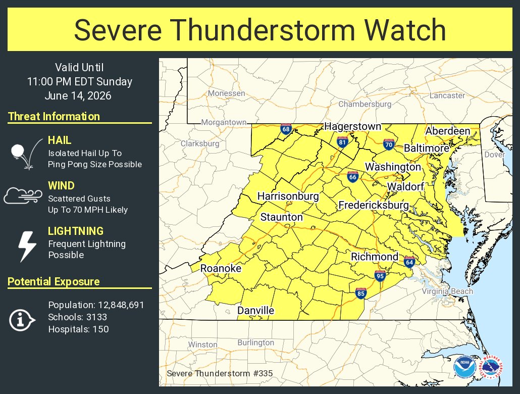
ALT This graphic displays Severe Thunderstorm watch number 335 plotted on a map. The watch is in effect until 11:00 PM EDT. The watch includes parts of District of Columbia, Maryland, Virginia and West Virginia. The threats associated with this watch are no tornadoes expected, isolated hail up to ping pong size possible and scattered gusts up to 70 mph likely. There are 12,848,691 people in the watch along with 3133 schools and 150 hospitals.


