

Chattanooga's favorite weather team: @DavidKarnes3 @ClayLocal3 @HannahLocal3 & @AudreyLocal3
Chattanooga, TN
Joined April 2009
- Tweets55.1K
- Following167
- Followers22.5K
- Likes365


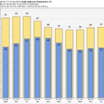
Good morning! We are starting the week with quiet conditions and chilly temperatures in the 30s and 40s. Patchy frost is possible before 8 AM, especially in our eastern communities.

Congratulations to Diane from Hixson. She won $290 from the September Degree Guarantee Jackpot! But this isn't Diane's first time, she won the 3 Degree Guarantee 22 years ago! And she was able to find the receipt!


Good morning! We are tracking dense fog in some areas this morning. Be careful on your morning commute!


Download the free Local 3 Weather app now. The power of Local 3 Storm Alert Team tracking the remains Isaias here in the Tennessee Valley. Keeping you prepared and informed. Go the app store and download the free Local Local 3 Weather app now.
Count on Local on Local 3 News and the Storm Alert Team for the very latest on the effects of Isaias here in the Tennessee Valley. Keeping you prepared and informed. Go the app store and download the free Local Local 3 Weather app now.
Count on Local on Local 3 News and the Storm Alert Team for the very latest on the effects of Isaias here in the Tennessee Valley. Keeping you prepared and informed.
Count on Local 3 and the Storm Alert Team to track Isaias keeping you prepared and informed. Go to the app store and download the Local 3 Weather app now.
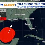
A broad area of low pressure has developed in the southwestern Gulf, just off the eastern coast of Mexico. The National Hurricane Center is now giving this system a 70% chance of becoming at least a tropical depression over the next 7 days. We will have to iron out the details throughout the week, but rain looks likely late Saturday into Sunday for now.
We will have a better idea of strength, timing, and possible local impacts from this system once a defined center of circulation develops. The next name up on the Atlantic hurricane list is Isaias (ees-ah-EE-ahs). More updates to follow!


INCREASING RAIN CHANCES THIS WEEKEND ⛈
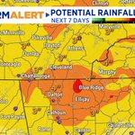
The pattern will begin to change this weekend as a cold front slowly moves across the Southeast. Rain and storm chances return Saturday and Sunday as southerly flow brings in moisture from the Gulf. Heavy rain will be possible at times, with most of our area seeing anywhere from 2 to 4" of rain. We will have a better idea of the exact timing and rainfall amounts in the coming days, but it looks like a wet weekend ahead!

Good Monday! The consistently pleasant weather continues its trend today, with clear skies and seasonably nice temperatures.
Click the link below to view weather forecaster Kinley Beshers's Monday midday forecast.


10:05PM Eastern Wednesday. We still have some pesky areas of moderate to heavy rain hanging out around the Tennessee Valley. We will see it taper off overnight with only a few spotty showers expected on Thursday. @[370698406298330]
7:35 PM radar update Wednesday. Spotty areas of heavy rain continue developing and moving southeast across the viewing area. Localized street flooding the primary threat. We could see these continuing to pop up through late evening. @DavidKarnes3
(9/23) Wednesday is our third consecutive Storm Alert Weather Day as we prepare for afternoon and evening THUNDERSTORMS.
The weekend will reward us with noticeably cooler temperatures!
FULL FORECAST UPDATE:

SPECIAL WEATHER STATEMENT (Tues. 9/22): For portions of Dekalb County, AL.
HAZARDS: 50 mph winds and penny-sized hail.

Happy Tuesday to the Tennessee Valley! Today is another Storm Alert Weather Day. Expect one more day of hot, humid conditions with partly cloudy/overcast conditions.
Radar Check 7:06 AM ET (9/22): Slow-moving heavy rain is making for a wet commute for our eastern communities. The heaviest rain is currently moving across Cherokee and Fannin Counties.

A Special Weather Statement is in effect for portions of Walker, Chattooga, Gordon, and Whitfield Counties until 5:30 AM ET (9/22). 40 mph wind gusts, heavy rain, and frequent lightning are possible with this cluster of storms.

