

The Autonomous Aerial Data Network. Created by @SpexiGeospatial 🏘️ https://xitter.cf/t.co/KcpPHWhtls
Earth
Joined April 2025
- Tweets1K
- Following139
- Followers43.3K
- Likes671




Pinned Tweet
Introducing the Spexi demo experience powered by LayerDrone: explore change in League City, TX, in seconds.
Over $1B in active development, 3,000+ acres in transformation, 4,000+ homes underway, refreshed on a set schedule.
See for yourself. No sales call, no credit card required. hubs.ly/Q04t4bwr0
Every flight. Ready for your model. Find @SpexiGeospatial at Booth #154 at Augmented Enterprise Summit in Atlanta, Oct 13–15, and see how scheduled, standardized drone captures turn into time-series data your models can actually use. #AES2026 #XR #digitaltwins #AI
#emergingtechnologies

One week to ITC Vegas 2026 and Spexi is an official sponsor.
Sep 29 - Oct 1, booth 2950.
If you're in property risk, underwriting, or claims and want to see what GIS-ready drone imagery looks like up close, come find the Spexi team on the floor.
Book time with the team or just stop by and say hi!
Still need a ticket? Save $200 with our link:
hubs.ly/Q04xQyGJ0
#ITCVegas #InsurTech #PropTech
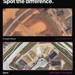
Same property in League City, TX. One capture from satellite, one from Spexi.
Same location, two very different levels of detail.
That gap is exactly what Spexi's free League City trial closes -- 2.8cm drone imagery, searchable in seconds, no contractor or flight coordination needed.
Try it free at hubs.ly/Q04xCqH70

On the show floor at Commercial UAV Expo, booth 1806. Come say hi whether you fly for us or work with our imagery. Always good to put faces to the work.

LayerDrone is heading to Commercial UAV Expo in Las Vegas, Sept 1-3! Catch us at booth 1806 all three days.
Flying with LayerDrone or thinking about it? Come talk shop with the team, walk through new capture opportunities, and see what's next for the pilot network in person. This is the spot to ask real questions and get real answers.
GIS users, come see what you can do with the imagery once it's captured, tracking construction progress, spotting change over time, and pulling site detail without setting foot on location.
Vegas, let's go.
#cuavexpo #vegas #drones

LayerDrone retweeted

This week's aerial capture at Prose Dickinson in League City, Texas. New oblique imagery shows current site conditions at Brentwood Cove and Palmetto Court. Weekly flights keep the record current as construction moves forward. See for yourself here 👉hubs.ly/Q04tj0Nm0

Fresh eyes in the sky over League City, Texas this week. Our latest flight over Prose Dickinson captured shots of Brentwood Cove and Palmetto Court, giving a full look at how this Alliance Residential project is taking shape. Construction never stops, and neither does our capture schedule.

Clearing has started at the Hines Lloyd Tract — a 1,500-acre master-planned development in League City, Texas.
Three aerial captures, same location.
This is what the very beginning of a development looks like from 200ft up. Before any structure, before any road — just equipment, cleared ground, and water management taking shape.
This is the layer our pilots build, flight by flight.
#LeagueCity #LayerDrone #Clearing #MasterPlanned #Hines #AerialImagery
Time-lapse from Prose Dickinson — Alliance Residential's multifamily development in League City, Texas.
Multiple weeks of aerial captures showing the full roofing phase across a large multi-building site. Open decks, sheathing, crew progression, completed shingles all visible from a single overhead perspective, week over week.
This is what a consistent aerial capture cadence produces. A dated, sequential record of a project as it actually progresses, not a snapshot taken once and forgotten.
#LeagueCity #PhysicalAI #Construction #TimeLapse
Curious what standardized drone imagery actually looks like?
We put together a sample gallery showing real examples — static captures, orthomosaics, 360° panoramas, and gaussian splats, all from one flight. Browse it here: hubs.ly/Q04sFTH90

New subdivision in Peterborough. Construction site in Calgary. Solar array in San Francisco.
LayerDrone pilots mapped all of it.
Every flight adds to the network. Every acre means more data for GIS teams that need it.
The network is growing. The data matters.
@SpexiGeospatial

Two days ago, Esri put @SpexiGeospatial on the UC Plenary stage in front of thousands of GIS professionals.
Today the Spexi team is on the floor at Esri UC booth 332 showing what that looks like in practice.
The imagery you've been capturing is now part of one of the biggest conversations in GIS.
#EsriUC
Esri UC. 17,000+ GIS professionals. And Spexi -- powered by you -- on stage.
Every acre the LayerDrone network has mapped is part of what made this moment possible.
The network is growing. The data matters. Keep flying.
@SpexiGeospatial #EsriUC

10,000+ pilots. 6M+ acres. And now, the Esri UC.
The imagery LayerDrone pilots capture is making it to the biggest GIS conference in the world.
Next week at #EsriUC, the community hears about Spexi in the Content Store for ArcGIS.
The network you're building matters. Keep flying.
@SpexiGeospatial

Esri UC starts July 13.
The imagery you've been flying is going to be on display — literally. Spexi drone orthomosaics are featured in the What In The World display at the conference, outside the Map Gallery between halls 20A and 20B.
17,000+ GIS professionals will walk past the data you helped build.
Keep flying. @SpexiGeospatial
#EsriUC
You fly. GIS professionals around the world buy the data.
LayerDrone pilots now power imagery that's available directly in the Esri Content Store for ArcGIS.
The network you're building just became part of one of the world's most important geospatial ecosystems.
Download the app. Fly. Earn.
@SpexiGeospatial

The imagery LayerDrone has been capturing is now available in the Content Store for ArcGIS.
Pilots built this. GIS teams worldwide can now buy it.
10,000+ pilots. 6M+ acres mapped. Now inside one of the world’s most important GIS ecosystems.
Keep flying. @SpexiGeospatial
What's the worst thing you've ever seen while flying a drone?
For @SpexiGeospatial pilot Duncan Smiff, it was their home... following a flood.

ALT A heavily flooded urban area, with multiple houses underwater.
What's the coolest thing you're drone has captured?
Everyday-anteater shared this answer in the @SpexiGeospatial x LayerDrone Discord 👇

ALT A storm forming at sunset.