SeminoleSAFE (a.k.a. KeepFSUSafe) is your source for safety information, preparedness education, crime prevention tips and more from Florida State University.

Florida State University
Joined January 2009
10/19/26 8AM ET 🌡️☔🔮🎲 One of the stronger El Niño events on record is here to stay into early next year: coralreefwatch.noaa.gov/data… This phenomenon is highly likely to make for a wetter-than-normal winter 2026-2027, per NOAA's outlook: noaa.gov/news-release/el-nin… #FLwx #GAwx #ALwx
1
13
28
3,550
10/10 550 am ET: Isaias weakened overnight and is now post-tropical. All Hurricane and Tropical Storm Warnings have ended. We are left today with a lingering threat of heavy rain and a tornado or two over the eastern Big Bend and south-central GA. #FLwx #GAwx #ALwx
1
9
2
24
7,715
355pm - The favorable environment for tornadoes still remains offshore as evidenced by this strong cell's broadening rotation. However, this favorable environment is lifting north. Tornado threat will increase into the late afternoon and evening across the Florida Big Bend. #FLwx
3:00pm ET - Watching a very strong storm with fairly significant rotation offshore the coast. This storm and ones associated with it along the northward moving boundary will need to be monitored for tornado potential. #FLwx #Isaias
14
53
4,559
11am Isaias Update: Tropical Storm/Hurricane Watches now in effect for many coastal locations across the northern Gulf. Storm surge watch in effect as well. #FLwx #ALwx #GAwx
31
3
63
13,225
SeminoleSAFE retweeted
Motorists are urged to avoid the area and use alternate routes as emergency crews respond. Lanes are currently closed along North Monroe Street from Apalachee Parkway north to Park Avenue and east to Franklin Boulevard.
2
2
5
1,918
SeminoleSAFE retweeted
The Tallahassee Police Department is currently assisting the Tallahassee Fire Department with a fire-related incident in the downtown area, east of the Capitol complex near the Leon County Courthouse.
2
4
1
20
5,268
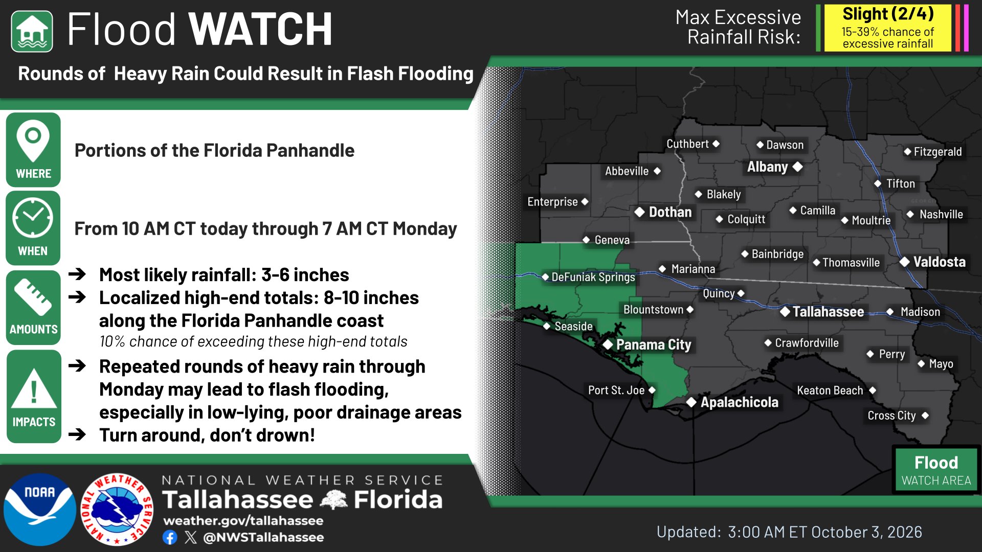
10/3/26: A Flood Watch is in effect for portions of the FL Panhandle this weekend into early Monday morning. Rainfall totals will generally rain between 3" to 6" in this area with locally higher amounts of 8"+. Elsewhere, 2" to 5" of rain are forecast the next few days.
3
5
13
2,505
9/18/26 8AM ET 🌧️📉🔮 After a dry couple of days, rain chances are on the rise this weekend into Mon. Scattered showers/storms return as high pressure weakens and a tropical wave moves from the FL Peninsula into the East Gulf. #FLwx #GAwx #ALwx
6
7
1,766
9/17: We're waking up to some crisp air, especially north of I-10 where many places are in the 60s. We'll reach the high 80s/low 90s with mainly sunny skies and a bit of a breeze. Rough beach/boating conditions continue today, but should improve in a day or two. #ALwx #FLwx #GAwx
4
15
2,032
5 PM AST Thu Aug 27 (Advisory 2) Key Messages for Tropical Storm #Dolly. Latest info: hurricanes.gov 5 PM AST jueves 27 de agosto (Aviso 2) Mensajes clave sobre la tormenta tropical #Dolly. Más información: hurricanes.gov
4
87
11
336
79,377
8/21/26 6am ET There is also another Heat Advisory in effect for the FL Panhandle & Big Bend, SE Alabama, and southern Georgia. Showers and storms are forecast to blossom this afternoon with the potential to see strong gusty winds up to 60 mph. #FLwx #GAwx #ALwx
7
11
1,849
8/20/26 7am ET There is a Marginal Risk of Severe Weather (level 1 of 5) this afternoon and evening for the potential to see strong gusty winds up to 60 mph. ⛈️ There is also another Heat Advisory in effect for the FL Panhandle & Big Bend, SE Alabama, and southern Georgia. 🥵☀️
4
1
7
1,846
Temps will warm up and remain that way for an extended period of time as high pressure controls the prevailing pattern. Expect multiple days of hazardous heat with heat indices of 105-110. #FLwx #ALwx #GAwx
5
1
2
2,987
As high pressure settles into the region the next few days, conditions will warm up while rain chances stay fairly isolated/scattered. Some heat index concerns creep into the forecast late in the week. #FLwx #ALwx #GAwx
3
6
2,468
7/27/2026, 530 am ET: 🥵Peak heat is on through Wed, concurrent with peak mugginess and peak heat index. Heat Advisory today. Extreme Heat Watch Tue. Take all hot weather precautions. ⛈️Strong to severe t-storms erupt late Wed as the heat wave starts to break. #FLwx #ALwx #GAwx
8
9
2,171
7/26/2026 It was HOT🥵out there today, with Apalachicola breaking a daily record with a high temperature of 94°F. Temperatures will continue to rise for the next couple of days with new records🌡️being tied or broken through the region with heat hazards issued! #FLwx #GAwx #ALwx
7
11
2,429
SeminoleSAFE retweeted
As we move through the 2026 hurricane season, we want to remind everyone that select hurricane supply items are tax free year-round to make sure that Floridians can be prepared well before a storm hits. For more tips and tricks on what you should be including in your disaster supply kit, be sure to check out bit.ly/4vIxLrj and follow our partners at @FLSERT for more hurricane preparedness resources!
1
12
3
25
3,999
No large changes overnight with Tropical Depression Two. It has only minimally strengthened over the last 24 hours and remains disorganized. Outer bands of TD2 will lead to a wet day, and building surf through the early part of the week. #FLwx #ALwx #GAwx
9
3
16
4,849
July 16th 9:40am ET - Lower rain chances again this afternoon, with most of the rain chances likely across the eastern portions of the forecast area.
5
14
2,527
7/14 - One more day of several rounds of showers and storms, some may produce gusty winds and locally heavy rainfall. Isolated instances of flash flooding will be possible, especially in poor drainage areas. ⛈️ A return to a summertime pattern begins tomorrow. #FLwx #GAwx #ALwx
1
5
10
1,961