Justin Mosely (@JustinMosely) header
Justin Mosely (@JustinMosely) profile picture

WFLA Max Defender 8 Meteorologist | AMS Approved | Proud Floridian | Tropical Weather Specialist | WFLA-WTTA-WSNN

Tampa, FL
Joined May 2012
Photo by Justin Mosely (@JustinMosely)Photo by Justin Mosely (@JustinMosely)Photo by Justin Mosely (@JustinMosely)Photo by Justin Mosely (@JustinMosely)Photo by Justin Mosely (@JustinMosely)Photo by Justin Mosely (@JustinMosely)Photo by Justin Mosely (@JustinMosely)Photo by Justin Mosely (@JustinMosely)Photo by Justin Mosely (@JustinMosely)Photo by Justin Mosely (@JustinMosely)
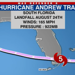
Incredible radar image of Hurricane Andrew at landfall, showing the well-defined eyewall and intense spiral rainbands across South Florida. Andrew left its mark in 1992 and became a benchmark storm in Florida history.
3
237
Today marks the 34th anniversary of Major Hurricane Andrew. A category 5 hurricane to make landfall near Homestead, FL in 1992. At the time, it had been 23 years since the last Cat. 5 storm struck the mainland United States. That was Hurricane Camille 1969.
1
4
550
Justin Mosely retweeted
Yesterday was a very busy weather day with record heat, rainfall and wind gust between 40 to 60 mph! Check out a few of the records we broke below.
7
28
3,204
RED HOT conditions remain in the forecast through the Father's Day weekend. Use caution & know your limits in this excessive heat. #SRQ #Lakeland #Tampa
1
3
227
Still tracking the remnants of Arthur moving across the southeastern US. There is a slight chance this area could regenerate offshore of the Mid-Atlantic as it moves away from land.
1
3
118
A Heat Advisory is in place today for the oppressively hot conditions. Feels like temps are already at or over 100 degrees for many locations & could go higher. Stay hydrated & stay cool! #Sarasota #Tampa #StPete
1
2
5
247
The “Echoes of Sarasota” exhibit is on display at City Hall & @vanwezelpah. Covering over 1,000 years, the free exhibition highlights stories that have shaped our City’s legacy. Stay tuned! An opening reception & more are in the works. Learn more: sarasotafl.gov/Echoes-of-Sar…
1
2
6
540
El Niño is officially underway! The equatorial Pacific is now above the 0.5c degree threshold & projected to strengthen in a big way! This bodes well to help suppress Atlantic Basin hurricane activity but also could mean a wet & stormy Winter Season for #FL.
1
9
330
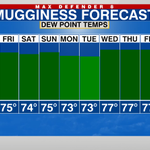
Humidity will continue to increase with Dew Points soaring into the upper 70s. Temps at night not cooling much, with lows staying in the low 80s to start each day next week. #SRQ #Tampa #StPete
1
3
395
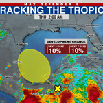
Tropics still mainly quiet. Just keeping an eye on the southern Gulf for a slight chance for development over the next week. Right now, this not a threat to FL.
1
3
143
HOT, HOT, HOT for the Bay Area! Air temps in the 90s today but with the soupy high humidity, heat indices will be around 100 degrees. Stay cool! #Sarasota #Tampa
6
214
Great day today in Sarasota for the Hurricane Awareness Tour! Thank you to @NWSTampaBay, @scgovEOC, @MCGPublicSafety, & @SRQAirport for hosting! Now off to Mobile, AL, for the tour on Tuesday with @NWSMobile. More info: weather.gov/mob/2026HAT#:~:t….
9
2
43
6,621
𝐂𝐨𝐥𝐝 𝐖𝐞𝐚𝐭𝐡𝐞𝐫 𝐒𝐡𝐞𝐥𝐭𝐞𝐫 Heads up! Due to an expected drop in temperatures, a cold weather shelter will be available in the Sarasota city limits at The Salvation Army of Sarasota County, 1400 10th St., today, Jan. 15, beginning at 7:00 p.m. More information ⤵️
Sarasota County Emergency Management officials have coordinated with municipal and community partners to provide cold weather shelter for those individuals in need due to the predicted drop in temperatures.
2
5
1,332
Justin Mosely retweeted
JUST IN: The 2025 Atlantic #HurricaneSeason ends on Nov. 30 with 13 named storms, including 5 hurricanes, of which 4 intensified to be major hurricanes. Find our news release, images and wrapup video at: noaa.gov/news-release/2025-a… @NWS
9
49
11
106
53,718
Justin Mosely retweeted
The heat continues on Tuesday! An Excessive Heat Watch has been issued for the Nature Coast counties, and a Heat Advisory has been issued for the rest of West Central Florida for Tuesday from Noon to 7 PM EDT. Be sure to stay hydrated and take extra precautions against the heat!
1
11
1
38
3,872
Extremely high moisture content in the air this afternoon with dew point readings topping 80 degrees in some locations. Dangerous heat indices for much of the #Suncoast in the triple digits. Stay hydrated & indoors during peak heating hours. #SRQ
1
4
366
Justin Mosely retweeted
Amazingly structured thunderstorm heading in as the sun starts to set🌅⛈️ We’ve had some severe storms this evening - if you have any reports of flooding or damage, let us know!! #flwx
9
72
3
268
17,132
Justin Mosely retweeted
Damage survey conducted in Pinellas County indicated EF-1 damage from yesterday's tornado, with maximum winds of 90 mph and a path length of just over 2 miles. While numerous structures received damage, no injuries have been reported.
The National Weather Service will be conducting a storm survey for the area near Largo in Pinellas County, FL. This is in relation to severe thunderstorms that moved through the area on 06/25/25 #flwx More details 👇 forecast.weather.gov/product…
2
42
6
169
34,054
Bradenton Mayor Gene Brown and his wife captured this amazing - yet scary - video of dual #waterspouts at the mouth of the Manatee River on Sunday. The Green Bridge is in the foreground. Drivers slowed and even stopped to witness the weather phenomenon. – at Palmetto, FL
9
42
1
243
14,255
Justin Mosely retweeted
A great time to prepare is now, before a storm threatens. #flwx
NWS Director Ken Graham shops for hurricane supplies on a calm, sunny day! 🛒☀️ No crowds, plenty of supplies, and zero stress – perfect for getting prepared. Be ready before the storm hits. Visit weather.gov/safety for more tips!
9
18
5,284