

Savannah Professional Firefighters Association / IAFF Local 574 Representing the Men and Women of the Savannah Fire Department.
- Tweets1.3K
- Following509
- Followers2.6K
- Likes1.5K


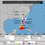


ALT Visual image of error cone for Tropical Storm Ian and text explaining that at the 5 pm update that Chatham County is under a Flood Watch until Oct 1, Hurricane Watch, Tropical Storm Warning and a Storm Surge Warning, rain fall potential is 2-4" for today and Friday, gusty winds with potential Tropical Storm force gusts. Elevated tides likely tonight and Friday morning.

ALT Visual image of error cone for Tropical Storm Ian and text explaining that at the 5 pm update that Chatham County is under a Flood Watch until Oct 1, Hurricane Watch, Tropical Storm Warning and a Storm Surge Warning, rain fall potential is 2-4" for today and Friday, gusty winds with potential Tropical Storm force gusts. Elevated tides likely tonight and Friday morning.

ALT Visual image of error cone for Hurricane Ian and text explaining that at the 5 pm update that Chatham County is under a Flood Watch until 8 AM Oct 1, Hurricane Watch, Tropical Storm Warning and a Storm Surge Warning, rain fall potential is 4-8" on Thursday and Friday, gusty winds with potential Tropical Storm force gusts. Potential for tornadoes.

ALT Visual image of error cone for Hurricane Ian and text explaining that at the 5 pm update that Chatham County is under a Flood Watch until 8 AM Oct 1, Hurricane Watch, Tropical Storm Warning and a Storm Surge Warning, rain fall potential is 4-8" on Thursday and Friday, gusty winds with potential Tropical Storm force gusts. Potential for tornadoes.


