Same mission, different platform. Our online presence has been moved to help support our new department Emergency Management and Communications! The department enhances coordination and strengthens service initiatives to the community.
Follow us on our socials! @FortWorthEMC
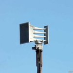
July 1st, 2026. Good morning #FortWorth Today the City of Fort Worth will be conducting our monthly audible test of the Outdoor Warning Siren System at 1 PM CST. This is only a TEST. #NWSfortworth #txwx #dfww
6/3/2026 Today's Fort Worth Outdoor Warning System test is canceled due to forecasted overcast skies and potential storms in the area. The system is tested audibly on the first Wednesday of each month at 1 PM, with silent tests on the remaining Wednesdays. #FortWorth #NWS #txwx
Good afternoon,
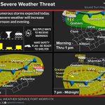
Scattered severe storms are expected this afternoon and evening and could bring the following:
- Large hail
- Damaging winds
- Locally heavy rain + isolated flash flooding.
OEM is monitoring the situation and we are ready to respond and support our community.
5/6/2026 Today's Fort Worth Outdoor Warning System test is canceled due to overcast skies. The system is tested audibly on the first Wednesday of each month at 1 PM, with silent tests on the following Wednesdays. #FortWorth #NWS #txwx
Check out this post on Nextdoor: nextdoor.com/p/LFtKZJqfnspk?…
Fort Worth Office of Emergency Management retweeted
A severe thunderstorm watch has been issued for parts of Texas until 2 AM CDT

ALT This graphic displays Severe Thunderstorm watch number 38 plotted on a map. The watch is in effect until 2:00 AM CDT. The watch includes parts of Texas. The threats associated with this watch are a couple tornadoes possible, scattered hail up to two inch size likely and scattered gusts up to 70 mph likely. There are 10,119,205 people in the watch along with 2721 schools and 166 hospitals.
3/4/2026
Today's Fort Worth Outdoor Warning System test is canceled due to overcast skies. The system is tested audibly on the first Wednesday of each month at 1 PM, with silent tests on the following Wednesdays. #FortWorth #NWS #txwx
Check out this post on Nextdoor: nextdoor.com/p/xJ9J_8P8Mp_M?…
1/23/2026
There have been minimal changes to the forecast during the past 24 hours other than minor refinements to timing and accumulation estimates.
A Winter Storm Warning is in effect for all of North Texas (beginning 6 PM this evening)
Fort Worth Office of Emergency Management retweeted
Here's the latest info for the upcoming winter weather event from Friday through the upcoming weekend. Finish your preparations during the next couple of days while temperatures are still mild!
Fort Worth Office of Emergency Management retweeted
1/07/26
Good afternoon #FortWorth Today the City of Fort Worth will be conducting our monthly audible test of the Outdoor Warning Siren System at 1 PM CST. This is only a TEST. #NWSfortworth #txwx #dfww
12/3/25 Good morning #FortWorth Today the City of Fort Worth will be conducting our monthly audible test of the Outdoor Warning Siren System at 1 PM CST. This is only a TEST. #NWSfortworth #txwx #dfwwx
111/25 take extra time for your commute in the morning and use extreme caution! #fortworth
Good Afternoon Fort Worth,
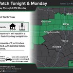
This afternoon into tomorrow, the Fort Worth area is under a “Marginal” Risk (1/5) for strong to severe thunderstorms and is also under a Flood Watch from 6 PM Sunday to 3 PM Monday.
Starting at 6 PM, spotty showers and thunderstorms will begin to enter the region, with the heaviest rain lagging behind it ahead of a frontal boundary. Similar to our last event, this system will bring two heavy waves of showers and thunderstorms. The first wave will arrive in Fort Worth around 1-2 AM on Monday, then around 5 AM the second and heaviest wave of storms will push through Fort Worth. This is when we will see our heaviest rainfall and strongest chance for severe weather, however the severe threat for North Texas is rather limited. After the second wave pushes through, showers and thunderstorms will continue until about 10 AM on Monday.
The main hazards with this system will be flash flooding, with a very low chance of hail and damaging winds, however most severe weather will occur south of the metro. Precipitation totals will most likely be between 1-3”, with the NWS calling for a 10% chance of precipitation up to 4”.
Stay tuned to NWS updates for the latest information on this developing system, and as always have multiple ways to receive warnings and stay weather aware!
#NWS #txwx #fwwx #dfwwx #KnowWhat2Do