


We are off to a chilly start across the Province this morning! The sun will shine across Newfoundland today while clouds are the rule in the Big Land, and the GNP will deal with some wind. #nlwx
sheerrweather.ca/monday-morn…

A Wind Warning goes into effect Monday afternoon for Port Saunders and the Straits. Gusts will reach ~100 km/h in many areas. Those high winds may extend to the other side of the Strait as well. #nlwx


A potent nor'easter will develop off the east coast of the US this week and will generate some large swells. As the storm departs the Outer Banks, it will pass Atlantic Canada, but the wave field will be smaller as it moves over the Grand Banks. #nlwx
Just added regional summary forecasts to the website that cover the Province. Check them out and let me know what you think! #nlwx
sheerrweather.ca/avalon/

WIND WARNING UNTIL EARLY AFTERNOON ON THE AVALON.
Wind gusts will be as high as 100 km per hour From the southwest and will be highest along parts of the coast. #NLWX
Posted October 17th, 2026 at 11:09 AM

The unsettled weather lingers into Sunday morning as our latest weather maker moves across Atlantic Canada
sheerrweather.ca/rain-wind-a… #nlwx

Another view of how the rain and snow will play out over the next 24 hours or so. #nlwx
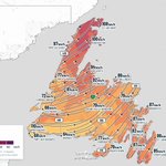
For those of you wondering how high the wind gusts will be, this map should give you a good idea. Many areas will see gusts of 70 to 100 km/h from the south-southeast to the south-southwest. #nlwx
Timing: The strongest gusts will generally occur during the first half of Saturday; the exception is the Wreckhouse area, where the strongest winds will occur tonight.
Posted: October 16, 2026

Wind Warnings go into effect tonight or tomorrow. #nlwx
sheerrweather.ca/wind-warnin…

Breezy and cool this morning, then sunny and cool this afternoon ahead our next storm system... #nlwx
sheerrweather.ca/friday-morn…

The next area of low pressure moves through between late tonight and late Saturday, bringing rain (mostly) to Newfoundland and snow (mostly) to Labrador. #nlwx
There will be some snow on the front end of this in the Long Range Mountains tonight, before a flip to rain, and parts of southeast Labrador will likely see a mix of both, especially along the coast.
This will also bring some wind, with gusts between 70 and 100 km/h across a large area of the Island. More on that later.
Meteorologist Eddie Sheerr | October 16, 2026

This is rain.
If it was a month from now, it would be accounting snow. Probably.
Winter is coming.
October 15, 2026
#nlwx

Another round of rain and wind will last parts of Newfoundland overnight before the sun returns for a brief stint Friday. However, another low moves in Friday night and will bring more rain, snow, and wind to NL through Saturday. #nlwx
sheerrweather.ca/one-low-dep…

Rain and wind are the story this morning, with a wind warning in effect for St. John’s, the northern Avalon and the Bonavista Peninsula until near noon. #nlwx
sheerrweather.ca/thursday-mo…

Ever wondered what the wind speeds are in the Wreckhouse area? Well, now you can find out every 2 minutes! #nlwx #nltraffic
sheerrweather.ca/wreckhouse/
