







Pinned Tweet
Introducing Ecopia’s Online Data Portal: unprecedented access to high-precision, AI-extracted mapping data for faster GIS & CAD workflows 🚀
4,353 miles of missing sidewalk. 134 miles ranked highest priority.
Explore how @WILMAPCO got from one number to the other, with Ecopia and @CitiesThatWork (Renaissance Planning) at the link in the comments. ⬇️
#Walkability #TransportationPlanning #PedestrianSafety #GeoAI

For a decade, Ecopia and @vantortech have turned satellite imagery into high-precision map data across every inhabited continent, from 20M buildings in Australia to 300M+ vectors across India.
Learn about the partnership in more detail at the link in comments. 🌎
#GeoAI #SatelliteImagery #Vantor #Mapping

Imagery this sharp = data this precise. 📍
Five ready-to-use GIS data packs built using our AI-powered feature extraction and @EagleViewTech's aerial imagery.
Learn about each and how they can be used at the link below.
#Geospatial #Eagleview #GIS #GeoAI

Nearly 139 miles of sidewalk in Woodstock, IL, mapped before a single crew went out.📍
DeepWalk integrates Ecopia's sidewalk data into its platform, so every project starts with a known scope instead of a guess. 🎯
Read the full story: **LINK**
#GIS #Infrastructure #GeoAI
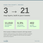
402 square miles. 3 vector layers to 21. 4 weeks.
Ecopia partnered with Hamilton County, Indiana to deliver a countywide AI land cover dataset, now powering 911 routing, ADA-accessible basemaps, and Indiana's first county 3D map viewer.
Full case study: hubs.ly/Q04tQd2_0

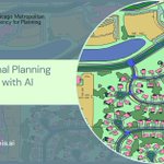
284 municipalities. 8.6 million residents. One regional dataset.
Ecopia partnered with @cmapillinois to deliver an AI map of northeastern Illinois, now powering road safety, flood risk modeling, and regional planning for 8.6M residents.
Full case study: hubs.ly/Q04sjjMJ0

The US saw 23 billion-dollar weather disasters in 2025, totaling 115 billion dollars in losses.
Ecopia's AI-powered 3D Land Cover data is helping communities plan smarter and respond faster to a changing climate.
Read the full blog here: hubs.ly/Q04rxj4N0

Inaccurate base data = inaccurate Civil 3D drawings.
In @CADIntentions most recent video, Brandon calls on Ecopia's high-resolution datasets as a reliable way to avoid common mistakes. Watch here: hubs.ly/Q04rp0lX0
🔗 Browse Ecopia's data: hubs.ly/Q04rnW3x0
#GeoAI
We are honored to be recognized on @geoawesome_dgtl Global Top 100 Geospatial Companies amongst such a talented group of organizations for the 5th consecutive year. 🚀
#Geoawesome100 #GeoAI #Geospatial
hubs.ly/Q04r8x2P0
From stormwater management to broadband network expansion, accurate geospatial data is the foundation for better civil engineering decisions. See Ecopia's AI-extracted data in action.
#CivilEngineering #GIS #Geospatial #AI #Mapping
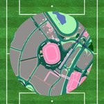
This is it. The FIFA World Cup 2026 Final. Spain vs Argentina. MetLife Stadium, New Jersey. One hour to kickoff. See it through Ecopia's AI. ⚽🇪🇸🇦🇷
#FIFAWorldCup2026 #Geospatial #GeoAI #Mapping #AI

France vs England kick off in one hour at Hard Rock Stadium in Miami. See the stage through Ecopia's AI mapping data.
#FIFAWorldCup2026 #Geospatial #GeoAI #Mapping #AI

One hour until England vs Argentina at Mercedes-Benz Stadium in Atlanta.
This is today's arena through Ecopia's AI mapping data.
#FIFAWorldCup2026 #Geospatial #GeoAI #Mapping #AI

Heading into Day 3 at @EsriUC 2026. 🚀
Come find us at Booth A13 in San Diego, we would love to connect!
#EsriUC #EsriUC2026 #GIS #Geospatial #Mapping


See how @cadintentions pulls geospatial data straight into AutoCAD/Civil 3D as ready-to-use Shapefiles, a game-changer for Civil Engineers & Designers. Check it out below!
🎥hubs.ly/Q04pnlKT0
🔗Free portal access + sample data: hubs.ly/Q04pmsX40

Our Building-Based Geocoding dataset now includes 180M+ building footprints 🏠
Check out our latest year-over-year building change analysis with an interactive map so you can explore the data county by county: hubs.ly/Q04mGpPR0
