

Dothan-Houston County's coordinating agency for disaster response, recovery and preparedness. For emergencies, call 911.
- Tweets3.2K
- Following201
- Followers2.1K
- Likes46











ALT Current Information & Forecast Positions:Center Location: $25.4^\circ\text{N}, 88.4^\circ\text{W}$ Max Sustained Winds: 105 mph Movement: NE at 14 mph 10 PM Thu: Major Hurricane ('M') 7 PM Fri: Hurricane ('H') 7 AM Sat: Tropical Storm ('S') 7 PM Sat / 7 AM Sun / 7 PM Sun: Tropical Depression ('D') Watches & Warnings Legend:Hurricane Warning (Red): Coastal SE Louisiana, Mississippi, Alabama, and Florida Panhandle. Tropical Storm Warning (Blue): Coastal SE Louisiana and Florida Panhandle. Tropical Storm Watch (Yellow): Inland Mississippi, Alabama, Georgia, and Florida. Map Description: Map showing the 5-day forecast cone for Hurricane Isaias curving northeast from the Gulf of Mexico, making landfall along the central Gulf Coast, and moving inland across the Southeast and Ohio Valley.

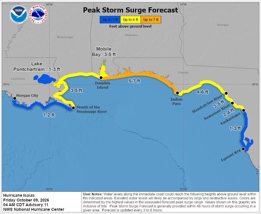
ALT Forecast Surge Levels:5-7 ft (Orange): Coastal Alabama and Florida Panhandle through Indian Pass. 4-6 ft (Yellow): Mobile Bay, Ocean Springs, and Indian Pass to Steinhatchee River. 3-5 ft (Yellow): SE Louisiana to Ocean Springs, and Steinhatchee River to Suwannee River. 2-4 ft (Yellow): Suwannee River to Yankeetown. 1-3 ft (Blue): Lake Pontchartrain, Yankeetown to Egmont Key. 1-2 ft (Blue): Morgan City to Mouth of the Mississippi River. Map Description: Coastal forecast map depicting peak storm surge inundation levels above ground level along the U.S. Gulf Coast from Louisiana to western Florida.


ALT National Hurricane Center forecast for Hurricane Isaias, issued October 8, 2026, at 10 AM CDT. Isaias has maximum sustained winds of 85 mph and is moving east-northeast at 10 mph. The hurricane is forecast to approach the northern Gulf Coast Friday evening, making landfall near the Mississippi-Alabama coastline before weakening as it moves inland Saturday and Sunday. Hurricane and tropical storm warnings are in effect along portions of the Gulf Coast, with additional tropical storm watches and warnings extending inland. Hazardous conditions can occur outside the forecast cone.

ALT National Hurricane Center map showing forecast peak storm surge from Hurricane Isaias along the northern Gulf Coast, issued October 8, 2026. The highest surge of 5–7 feet above ground level is forecast from Ocean Springs, Mississippi, through Mobile Bay, Alabama, to Indian Pass, Florida. Surge of 4–6 feet is forecast from Indian Pass to the Steinhatchee River, with 3–5 feet along portions of southeastern Louisiana and Florida's Big Bend. Lower surge of 1–3 feet is forecast along portions of coastal Louisiana and farther south along Florida's Gulf Coast. Values represent potential water heights above normally dry ground.


ALT This graphic displays a severe thunderstorm warning plotted on a map. The warning is in effect until 6:45 PM CDT. The warning includes Taylor AL, Ashford AL and Slocomb AL. This warning is for Eastern Geneva County in southeastern Alabama and Southwestern Houston County in southeastern Alabama. The threats associated with this warning are wind gusts up to 60 MPH and pea sized hail. There are 37,175 people in the warning along with 13 schools and 0 hospitals.

ALT This graphic displays a flash flood warning plotted on a map. The warning is in effect until 8:30 PM CDT. The warning includes Dothan AL, Headland AL and Midland City AL. This warning is for East Central Dale County in southeastern Alabama, Southern Henry County in southeastern Alabama and Northeastern Houston County in southeastern Alabama. Avoid walking or driving through flood waters! Move immediately to higher ground! There are 101,896 people in the warning along with 30 schools and 5 hospitals.

ALT This graphic displays a severe thunderstorm warning plotted on a map. The warning is in effect until 6:15 PM CDT. The warning includes Ashford AL, Cottonwood AL and Columbia AL. This warning is for Eastern Houston County in southeastern Alabama. The threats associated with this warning are wind gusts up to 60 MPH and penny sized hail. There are 10,399 people in the warning along with 5 schools and 0 hospitals.