

Challenging the long-standing misrepresentation, bringing awareness to the importance of accurately representing Africa on the world map.
Africa
Joined January 2025
- Tweets27
- Following4
- Followers193
- Likes1


Correct the Map retweeted

Prof Lopes says representation through an accurate map matter, and asks why is it that Google maps still uses the outdated the Mercator map? The distance between the Eastern and Western coast of Africa is as vast as Russia but this is not on maps.#CorrectTheMap #SizeMatters
Correct the Map retweeted
Prof Lopes is unpacking stereotypical perceptions, and how African are associated with conflict, even when other parts of the world experience it to a greater degree. He says these projections are not accurate.
"Made up."
#CorrectTheMap #SizeMatters
Correct the Map retweeted
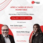
Follow the conversation on YouTube to find out why the world map is a big fat lie, and why this matters.
#CorrectTheMap #SizeMatters
Correct the Map retweeted
Welcome to the Africa Taking Up Space Roundtable. Today’s conversation is discussing why the world map is a big fat lie, and why this matters.
#CorrectTheMap #SizeMatters
Correct the Map retweeted

First attempt at #woodcarving a #worldmap using the #EqualEarthProjection by @BojanSavric, @mappingbernie & @MtnMapper. Needs some tweaking, but looking good!


