

Official account of Clemson University Public Safety. For emergencies, call or text 911.
- Tweets1.2K
- Following92
- Followers9.3K
- Likes89


ALT What is social engineering? Social engineering is when cybercriminals manipulate people into giving up sensitive information.


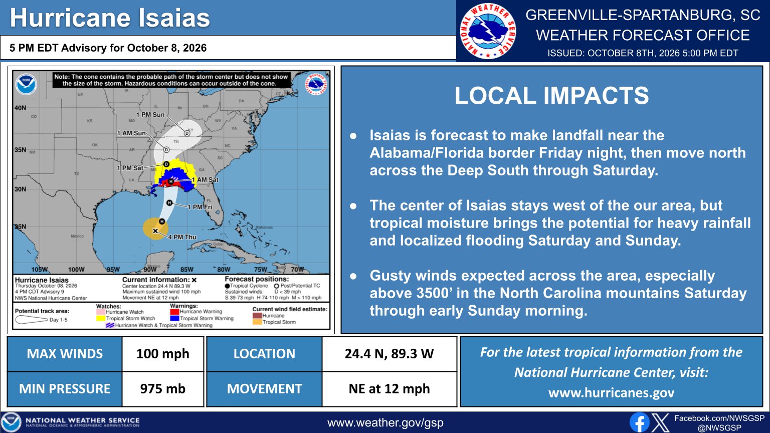
ALT NWS Greenville-Spartanburg Hurricane Isaias briefing issued at 5 PM EDT October 8, 2026. Isaias is forecast to make landfall near the Alabama/Florida border Friday night before moving north through the Deep South. The storm's center is expected to remain west of the western Carolinas, but tropical moisture could bring heavy rainfall and localized flooding Saturday and Sunday. Gusty winds are expected across the region, especially above 3,500 feet in the North Carolina mountains Saturday through early Sunday. Isaias has maximum sustained winds of 100 mph and a minimum pressure of 975 mb.

ALT NWS Greenville-Spartanburg storm total rainfall forecast from Friday evening, October 9, through Monday morning, October 12. Rainfall totals of 3–4 inches are forecast along portions of the Blue Ridge Escarpment, including Brevard, Tryon, and Marion, where localized flash flooding is a concern. Totals of 1.5–3 inches are expected across much of Upstate South Carolina and northeast Georgia, with generally 1–2 inches across the North Carolina Piedmont. Compared to the previous forecast, rainfall amounts have decreased across the Piedmont but increased along the Blue Ridge Escarpment.


ALT This graphic displays a severe thunderstorm warning plotted on a map. The warning is in effect until 4:15 PM EDT. The warning includes Seneca SC, Central SC and Norris SC. This warning is for Southwestern Pickens County in Upstate South Carolina and East central Oconee County in Upstate South Carolina. The threats associated with this warning are wind gusts up to 60 MPH and quarter sized hail. There are 56,105 people in the warning along with 11 schools and 1 hospital.


ALT This graphic displays a special weather statement plotted on a map. The statement is in effect until 9:15 PM EDT. The statement includes Clemson SC, Seneca SC and Central SC. The threats associated with this storm are wind gusts up to 40 MPH and pea sized hail. Seek shelter in a sturdy structure until the storm passes.


ALT This graphic displays Severe Thunderstorm watch number 660 plotted on a map. The watch is in effect until 9:00 PM EDT. The watch includes parts of Georgia, North Carolina and South Carolina. The threats associated with this watch are no tornadoes expected, isolated hail up to quarter size possible and scattered gusts up to 70 mph likely. There are 5,758,836 people in the watch along with 1361 schools and 112 hospitals.

ALT This graphic displays Severe Thunderstorm watch number 656 plotted on a map. The watch is in effect until 8:00 PM EDT. The watch includes parts of North Carolina and South Carolina. The threats associated with this watch are no tornadoes expected, isolated hail up to ping pong size possible and scattered gusts up to 70 mph likely. There are 10,799,242 people in the watch along with 2598 schools and 164 hospitals.


ALT Graphic titled "Danger Heat Indices Continue Through the Week". Map on the right shows heat indices for Wednesday, September 2, 2026, mainly in the lower 100s east of the mountains. Heat steadily builds through at least Friday. Avoid strenuous outdoor activity and stay hydrated!