Data Scientist ~ Cities + Statistics + Art ~ ABBA Enthusiast ~ #MetBrewer Creator ~ Cowboy at Heart ~ 🏳️🌈
NYC
Joined April 2021
- Tweets363
- Following441
- Followers1.9K
- Likes4.1K
Pinned Tweet
✨✨ New Package ✨✨
Happy to announce that I am soft launching another R color palette package, {MoMAColors} today! Currently has 35 palettes based around artwork at @MuseumModernArt.
Download Instruction and Palettes here: github.com/BlakeRMills/MoMAC…
#r4ds #dataviz #rstats
Blake Robert Mills retweeted
NYC blocks, colored by how much they are not rectangles
(Basically a joke, it's not a well-defined problem).
Blake Robert Mills retweeted
Today I bring you a little passion project: GhibliBrewer, an R package by @javiml221098 and me, to create color palettes taken from Studio Ghibli movies! 🖌️ Our work is based on the amazing MetBrewer package from @BlakeRobMills, let's deepen into it 🧵
Blake Robert Mills retweeted
🔉Next stop... MetroBrewer! 🚉
📦New package for #rstats developed by @iramosgutierrez and me!
📊Plot your graphs using your favorite metro map colors!
🔮Package inspired by @BlakeRobMills (MetBrewer)
👉Check it out on: juliagdealedo.github.io/Metr…
Still finishing a few maps I missed. Day 26 of the #30DayMapChallenge - Minimal. Spent forever creating the 8-bit icons for this Manhattan Map. Highly encourage everyone to check out the full image for detail!
Code: bit.ly/47RD8Js
Full Image: bit.ly/3TgerCa
Using today to finish my skipped entries. Day 5 of the #30DayMapChallenge - Analog Map. Map shows the location of plants in my apartment. Slightly cheated using Procreate, but that is my true, messy handwriting 🪴🌿🌵
Full Image: bit.ly/3RowvJ8
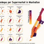
Day 28 of the #30DayMapChallenge - Is this a map or a chart?. Map/chart shows the number of bodegas for each supermarket in Manhattan.
Code: bit.ly/3R58LIA
Full Image: bit.ly/3uH9A2T
#rstats #dataviz #tidyverse
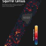
Day 29 of the #30DayMapChallenge - Population. Map shows number Squirrels in Central Park from the 2018 Squirrel Census 🐿️🐿️
Code: bit.ly/3uLiYCr
Full Image: bit.ly/46CTRPH
#rstats #dataviz #tidyverse #MoMAColors
Day 27 of the #30DayMapChallenge - Dot. Map shows number of 311 call requests for new trees in Manhattan.
Code: bit.ly/3T0Ju4S
Full Image: bit.ly/46vHeG4
#rstats #dataviz #tidyverse #MoMAColors
Day 25 of the #30DayMapChallenge - Antarctica. Map shows earthquakes around the continent.
Code: bit.ly/3t3lt2u
Full Image: bit.ly/49Or6Ci
#rstats #dataviz #tidyverse #MoMAColors
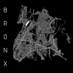
Day 24 of the #30DayMapChallenge - Black and White.
Code: bit.ly/47sme4r
Full Image: bit.ly/3uEjgek
#rstats #dataviz #tidyverse
Day 22 of the #30DayMapChallenge - North is not always Up. Map shows the wards of NYC in 1852 based on a map at the Brooklyn Library (linked in comments)!
Code: bit.ly/49VLNMW
Full Image: bit.ly/47uZfWb
#rstats #dataviz #tidyverse #MoMAColors
Based on this 1852 Map of New York City from the Brooklyn Public Library
mapcollections.brooklynhisto…
Day 21 of the #30DayMapChallenge - Raster. Maps shows the elevation of NYC boroughs and all neighborhoods with the name "Heights."
Code: bit.ly/49SiQRG
Full Image: bit.ly/40PzkGk
#rstats #dataviz #tidyverse #MoMAColors
Day 20 of the #30DayMapChallenge - Outdoors. Map shows the vegetation of Great Smoky Mountain National Park.
Code: bit.ly/40N4aPS
Full Image: bit.ly/3QRdkGh
#rstats #dataviz #tidyverse #MoMAColors
Day 19 of the #30DayMapChallenge - 5 Minute Map. Might have gone over by a minute or two 👀 A map of my neighborhood – Harlem! A Frankenstein of code from previous days.
Code: bit.ly/47JYPuH
Full Image: bit.ly/3SQsMFj
#rstats #dataviz #tidyverse
Day 18 of the #30DayMapChallenge - Atmosphere. Maps shows the concentration of PM2.5 in the different boroughs of NYC.
Code: bit.ly/47xCNvk
Full Image: bit.ly/40JQGUZ
#rstats #dataviz #tidyverse


![Map displays the number of squirrels in Central Park (2018].
Dots are sized and colored to represent the number of squirrels in the surrounding area.](https://pbs.twimg.com/media/GAJBiFnXEAA6FCs.jpg?name=small&format=webp)