

Meteorologist, @NEWSCENTERMaine | Former Chief Meteorologist, @kiii3news | Certified by the National Weather Association | Avid Golfer | @UTSA & @msstate Alum
Portland, ME
Joined March 2009
- Tweets17.5K
- Following167
- Followers4.4K
- Likes759






Halloween is still eight days out, but the longer range trend looks promising for a quieter (and perhaps mild) Halloween in Maine. Forecast guidance is suggesting a ridge of high pressure building over much of the Eastern US, including Maine.


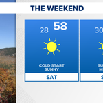
OCT 24/25 Weekend will feature chilly nights/mornings and mild afternoons. Sunny skies throughout with a light NW breeze Saturday and a light SW breeze Sunday. Enjoy!


Probably going to have frost delays on courses throughout Maine Saturday morning; widespread 20s expected. But Saturday ends up pretty nice with highs in the upper 50s, light winds, and sunshine. Enjoy!

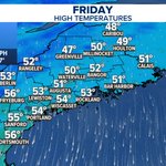
OCT 23 | It'll turn cold this evening as winds settle down and skies stays clear. If you're out at any high school football games, temperatures will be in the upper 30s by the end of games. Bundle up!

North winds will remain blustery through Friday morning, relaxing by mid/late afternoon. High temperatures in the middle to lower 50s under sunny skies.


OCT 22 | Filtered sunshine (high clouds) and high temperatures in the mid-upper 50s/low 60s; 40s north. North winds ramp up in the afternoon and will gust in the 20-30 mph range at times.


Wispy, upper-level cirrus over Casco, Maine, this Wednesday afternoon. Pretty.
We'll see this cloud type again, Thursday.

The storm off the East Coast has been dubbed Subtropical Storm Josephine. For Maine, waves come up to around 6-8 ft. Wednesday night/Thursday morning, and north winds pick up Thursday PM/Friday AM, gusting up to around 30 mph from the north.


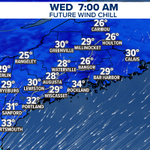
North wind won't be terribly strong (around 10 mph), but it'll be enough to put wind chill values in the middle to upper 20s and lower 30s Wednesday morning.

Thought about plotting a dual y-axis with wind direction on the right, but then found it easier to just say that gusts up around 30 mph will be from the north Thursday PM/Friday AM.

As a coastal storm exits east and a region of high pressure moves in from the west, the squeeze on the atmosphere between the two will increase north winds in Maine. Thursday late afternoon through Friday morning will likely have gusts up around 30 mph at times.


A storm will pass by Maine WED/THU (OCT 21/22) too far off-shore to deliver rain, but close enough to send in rough surf. Waves likely come up to around 6-8 ft. on area beaches late Wednesday and early Thursday.


Was poking around on our maps and realized you can see what's left of the old Beechridge Motor Speedway in Scarborough. My dad took me here a few times in the 90s. I remember watching cars crash over the sand berm walls into the trees.

OCT 19 | The week ahead looks pretty quiet and seasonal in Maine. May have a few showers around with a cold front moving in on Friday, but aside from that, forecast is benign.

The last time the high temperature didn't hit 50° or higher in Portland, Maine, was back on April 30. That may happen, Saturday. NW winds will gust up to around 30 mph, giving them a bit of bite considering the temperatures.

A cold front moving into Maine from the west will deliver a round of showers as it works east, through about 10/11p. There are some stronger storms working through Southern New England, but we aren't expecting anything strong in Maine; although an isolated rumble is possible.

OCT 16 | There is a chance for a passing shower to move over some of tonight's high school football games in Maine. Temperatures will be fairly mild, in the middle to lower 60s. Smart to bring some rain gear in case.
