

39 year old Orient supporter since 1997, love my music from Rock to Classical and everything inbetween. 🎵🎸🎤🎷🥁🎻🎶
London, England
Joined January 2025
- Tweets12.8K
- Following508
- Followers396
- Likes12.8K






Pinned Tweet
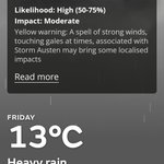
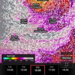
The @metoffice have officially issued an extended Yellow level wind warning for #StormAusten covering an area stretching from north Wales through the Midlands and down through East Anglia, London and surrounding home counties of Essex and Kent, gusts ranging from 45-55mph can be expected especially in exposure near coasts and on higher ground like the South Downs and Chilterns.
Localised disruption to transport can be expected where the strongest gusts occur, there will also be spells of torrential rain with local flash flooding possible.
Peak winds expected around late afternoon / early evening.


Adam Knight retweeted

People don't realise just how destructive these deep Atlantic low-pressure systems can be.
The majority of named storms in the UK produce gusts equivalent to Category 1 hurricane-force winds, with some reaching Category 2 and a few in recent history even reaching Category 3. Although these are gusts rather than sustained winds, they can still cause significant damage and pose a serious threat to life.
A prime example is Storm Eunice in 2022, when The Needles on the Isle of Wight recorded a 122mph gust, equivalent in speed to a mid-Category 3 hurricane. Even more incredibly, hourly mean winds at the site reached around 94mph at one point.
This satellite imagery shows Storm Austen moving away from the UK, having caused significant disruption, particularly across the South West, with gusts of around 80mph recorded at official weather stations. Meanwhile, Storm Boelo is expected to impact northern parts of the British Isles tomorrow, with gusts of 80–90mph possible, particularly across north-west Scotland.


Winds have really picked up in the past half an hour or so here accompanied by heavy rain too.
#StormAusten
Literally barely a breath of wind here so far in Essex just grey and drizzly. 🤔
#StormAusten
Adam Knight retweeted

The last of my #StormAusten video spam. Powerful gusts, but also a very strong sustained wind.
Adam Knight retweeted
Lots of reports on local Facebook of trees down, roads blocked/closed, power lines down and minor structural damage, mainly roof tiles, across Cornwall this morning. Some schools have closed and bus, road, rail and air travel have all been impacted.
#StormAusten


Adam Knight retweeted
The National Grid are reporting "several thousand properties" are currently without power in Cornwall. We can see near constant 'power flashes' from electrical arcing or transformer damage here in Hayle which I'm sure is related.
#StormAusten
Adam Knight retweeted
#StormAusten battering #Cornwall this morning. There's definitely going to be plenty of fallen trees blocking roads during the morning commute, the trees still in full leaf are taking a hit.
Adam Knight retweeted
#StormAusten is starting to move away from the UK, but strong, gusty winds are still expected across central and eastern areas around midday today, lasting into tonight. Gusts of 45–55mph are possible, especially in exposed areas.
#StormAusten has already caused significant impacts across the South West, with reports of widespread fallen trees, blocked transport routes and minor structural damage.
It’s not officially confirmed, but there are reports of weather stations recording individual gusts of around 100mph across the far South West, which is absolutely nuts!
If you have any videos of the wind or damage and would like to share them, feel free to send them over and I’ll post them for you!

Adam Knight retweeted
Top #StormAusten gusts so far:
*97mph NCI St Ives
*94mph NCI Gwennap Head
*81mph NCI St Agnes Head
*80mph NCI Rame Head
76mph Scilly, St Mary's
76mph Newquay
76mph Guernsey
73mph Jersey
71mph Culdrose
68mph Camborne
*unofficial but considered reliable for the exposed locations.
If only @ben_wadey had made such a big deal of Zoe Slaters character when she was still alive as he has done now she is dead. #EastEnders
Adam Knight retweeted

According to the @metoffice app, my area is going to see hurricane force winds tomorrow..
Given a category 1 hurricane starts at sustained winds of 74mph (not 32mph) this seems a little.. silly.

Adam Knight retweeted

Cyclone Austen Advisory 10
Winds: 90 mph
CWSIS: Category 2 (C2)
MSLP: 978 mb
Next Update: 5:00 PM
Potential Threat Area: Channel Islands, England, France, Belgium, and the Netherlands
CURRENT SITUATION
Storm Austen is being monitored as a powerful cyclonic windstorm, with reported winds of 90 mph and a central pressure of 978 mb. The system is classified as Category 2 cyclone on the CWSIS scale.
FORECAST TRACK
The projected track indicates continued east-northeastward movement toward the British Isles and Western Europe, with the Channel Islands, England, France, Belgium, and the Netherlands identified as potential threat areas.
WIND WARNING AREAS
The tracking graphic highlights areas across the Channel Islands and Western Europe for continued monitoring. Potential hazards include damaging wind gusts, coastal impacts, fallen trees, and travel disruption.
AMBER WIND WARNING
Areas within the projected path should be monitored closely for the possibility of severe wind impacts. Any official amber warning status should be confirmed through the relevant meteorological authorities.
INTENSITY OUTLOOK
With reported winds of 90 mph and a minimum central pressure of 978 mb, Storm Austen is classified as a Category 2 windstorm within the supplied tracking scenario. Further changes in intensity will depend on its future development and updated observations.
AREAS TO MONITOR
The Channel Islands and surrounding coastal waters
Southern and Southeastern England
Northern and western France
Belgium and the Netherlands
These areas are identified as potential threats based on the supplied advisory and should not be interpreted as confirmed impact forecasts.
NEXT ADVISORY
Next scheduled update: 5:00 PM.
Cyclone Tracking will continue to monitor Storm Austen's position, wind intensity, central pressure, projected trajectory, and potential warning areas as new information becomes available.
#StormAusten #WeatherAware #WeatherUpdate #Windstorm
CYCLONE TRACKING — FOLLOW THE TRACK. MONITOR THE INTENSITY. WATCH THE WEATHER EVOLVE.

Adam Knight retweeted
Finalised Wind Outlook for Storm Austen TMR:
I have removed the Level 4/5 risk for very severe wind gusts due to downtrends in modelled peak gusts, with maximum gusts now expected to reach around 75mph in the far SW.
I have also extended the Level 2/5 risk further up the eastern coast for very strong wind gusts. The coast should bear the brunt of the winds, and there remains a possibility of very strong gusts in these areas.
Overall, a less severe setup than what was shown 2 days ago, but Storm Austen could still bring some significant impacts.
Models are now in agreement on the track, so this is becoming more of a nowcast situation as the storm approaches relatively quickly.
The Wind Risk Guide is shown to the right of the Wind Outlook, explaining the potential impacts from gusts within each wind range. However, please follow the Met Office for official advice and warnings.


WIND OUTLOOK ISSUED FOR FRIDAY–SATURDAY — Named Storm:
ECMWF, UKMO and GFS are all indicating the potential for very severe wind gusts, particularly across the far South West.
The Isles of Scilly, including Hugh Town, could see gusts exceeding 85 mph. The islands are highly exposed to the open Atlantic, off England’s far south-western extremity, with little shelter from strong W–SW Atlantic flows. Gusts of 80–90 mph may also be possible around Land’s End and other exposed parts of the far South West mainland.
LEVEL 4/5 — ISLES OF SCILLY:
Very severe gusts exceeding 85 mph are possible. Significant disruption is increasingly a concern, with the potential for serious structural damage, widespread fallen trees, blocked transport routes and disruption to essential infrastructure.
LEVEL 3/5 — EXPOSED COASTAL AREAS AND OFFSHORE WATERS:
Gusts of around 70 mph or more are possible, particularly out to sea and across exposed coastal locations. Some coastal areas could experience these gusts, with the possibility of stronger winds reaching further inland. However, confidence in the inland extent remains relatively low, so this level is focused mainly on the more exposed areas.
Falling trees and branches, roof damage, and significant disruption to road, rail and ferry services are possible.
LEVEL 2/5 — PARTS OF WESTERN AND SOUTHERN UK:
Very strong gusts exceeding 55 mph are possible across some inland areas of western and southern England, Wales, and potentially further afield. These gusts could bring localised disruption, particularly in exposed locations, with falling branches and difficult driving conditions possible.
LEVEL 1/5 — WIDER UK AND ALL OF IRELAND:
Strong gusts of 40–50 mph could occur more widely throughout Friday across parts of the UK and the whole of Ireland, including southern Scotland. While impacts are expected to be more limited than in higher-level areas, locally difficult travel conditions, falling branches and isolated disruption remain possible, particularly in exposed locations.
IMPACTS AND HAZARDS:
The Isles of Scilly and the far South West mainland, particularly around Land’s End, could face the greatest risk of disruption. Large waves, dangerous swell and hazardous maritime conditions are possible around exposed western and southern coasts. A storm surge and coastal flooding could also become concerns if strong onshore winds coincide with high tide, although the extent of any surge remains dependent on the storm track and tidal timing.
Those living across the South West, western Wales and southern coastal areas should stay alert to forecast updates on Friday. Conditions at sea could become particularly dangerous for sailors and other mariners, while ferry services may be disrupted.
MY PERSONAL ASSESSMENT:
In my opinion, an Amber wind warning should be issued for the far South West if the current model guidance persists, with gusts of 80–90 mph possible in exposed coastal locations. I am fairly confident that the overall outlook will remain very similar, with the main areas of concern and the potential for severe gusts likely to stay broadly unchanged. However, exact wind speeds and the extent of the strongest gusts could still change as we get closer to the event. This is my own assessment, not an official warning.
This is a personal outlook intended to highlight potential impacts. Please follow the Met Office and relevant local authorities for official warnings and safety advice.
OVERALL CONFIDENCE LEVEL:
★★★★☆ — 4/5 (High Confidence)
I have high confidence that the overall outlook will remain broadly similar as we approach Friday, with the far South West continuing to be the main area of concern. Current model guidance indicates the potential for very severe gusts, particularly across the Isles of Scilly and exposed coastal areas near Land’s End. However, confidence in exact gust speeds, the storm’s track and the inland extent of the strongest winds is lower, and these details may still change as further model runs become available.

Adam Knight retweeted

⚠️ Yellow weather warning issued ⚠️
Wind across parts of Wales and England
Friday 1000 – 2100
Latest info 👉 bit.ly/WxWarning
Anyone just get this newly issued yellow level wind warning from the @metoffice regarding #StormAusten?
Seems like it only briefly popped up but has disappeared again! 🤔

Arpege seems to be the rebel amongst current computer model output on the track of #StormAusten but if it were to prove correct then. 👀
