

South Florida's Storm Team! The latest weather & storm updates brought to you by our @WSVN weather team! Send your weather photos with #SendItTo7
Miami / Fort Lauderdale
Joined June 2009
- Tweets75.1K
- Following77
- Followers38K
- Likes7K




7 Weather retweeted

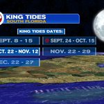
Winds to cause plenty of troubles over the next few days. Small Craft Advisories for all Coastal Waters. Tidal Flooding possible for the Upper Keys thru Miami-Dade & Broward Coastal areas from King Tides. Rip Current threat remains high at the beaches.
7 Weather retweeted
If models are correct, this weekend could be very soggy. There's a 15% chance over yellow area for excessive rainfall. 3 - 5" are possible which could lead to street flooding issues. King Tides may limit drainage.

7 Weather retweeted
The next Stretch of King Tides for the Mainland begins Oct 22nd and runs thru Nov 12th. The "extra high" high tides, may lead to flooding of low lying areas. They may impede rainfall drainage over the weekend. Heavy rain is being forecast by models.


7 Weather retweeted
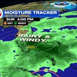
Long Range Forecast: Shows FL stuck between high/low pressures. This will keep the wind flow out of the NE. A large pool of moisture to our East will get drawn into South Florida by the weekend. This could lead to street flooding. King Tides may prevent rain drainage.
7 Weather retweeted
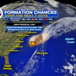
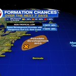
Tuesday Evening Tropical Update: #Invest93L may develop subtropical characteristics. By Friday, it speeds NE away from the US. Conditions become unfavorable for subtropical/tropical development. It'll cause winds, coastal flooding, & dangerous surf along portions of the U.S.


Tuesday Evening Tropical Update: #Invest93L may develop subtropical characteristics. By Friday, it speeds NE away from the US. Conditions become unfavorable for subtropical/tropical development. It'll cause winds, coastal flooding, & dangerous surf along portions of the U.S.


7 Weather retweeted
The Keys released their wind gust data for Tuesday. Key West had the strongest at 32 mph.

7 Weather retweeted
Area of Low pressure offshore the East Coast, is being watched by NHC. Even without development, it'll morph into an Nor'easter, and cause windy conditions and rough surf for the NE. This model suggests most of the rain staying offshore.


7 Weather retweeted
An area of low pressure offshore the Eastern Seaboard remains w a 40% chance for development somewhere inside orange area. Gusty winds, rain, & high surf for parts of the NE are possible.


7 Weather retweeted
Due to strong onshore winds, beach and boating conditions are not favorable. Small Craft Advisories persist, high risk of rip currents remain at the beaches, & a High Surf advisory is in place for Broward's Coastal waters. The Upper Keys may see some Salt Water flooding.


