

WTUS is a group of Student Meteorologists and Enthusiasts, providing you with the latest weather information & research, with no hype. Follow for more!
United States
Joined April 2021
- Tweets67.7K
- Following227
- Followers34.8K
- Likes22.6K
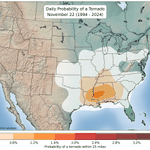


Traditionally the Deep South sees the most tornadoes in November (in fact this weekend is the 34th anniversary of the Nov 21-23, 1992 outbreak).
However, given a very strong influence by El Nino, Florida will likely see a well-above average tornado season, which generally peaks from November through March.


Potentially large tornado near Boca Raton, FL earlier.

Possible funnel with power flash. Atlantic Ave & FL Turnpike #southfla heading due east. @MaxVelocityWX @WPTV @CBS12
A broken line of storms, some of which are exhibiting rotation is moving across Southeast Florida this evening, in an environment supportive for a couple of tornadoes.
Enlarged wind profiles with moderate instability will support a wind & tornado threat over the next few hours.


A Tornado Watch has been issued for portions of Southeast Florida until 10pm EST.
A couple of tornadoes will be possible.


A tornado-warned supercell is ongoing near Boca Raton & Delray Beach, FL, and could produce a tornado soon.
Take cover now!

Check out the tornado-warned cell east of Hollister, CA earlier near Pacheco & Henrietta Peaks. No tornado was confirmed, but some pretty neat views from the nearby ALERTCalifornia cameras.
Portions of Central Florida are under another HIGH Risk of Excessive Rainfall (Flash Flooding) today.
While rain amounts may be lower than yesterday, already oversaturated soils, due to extreme rainfall the past couple of days will lead to a high threat of flash flooding.
As the weak upper low moves north, the flood threat will move north up the East Coast of FL as well, with significant flash flooding possible existing north of the main High Risk area.


More widespread heavy rain will impact Eastern Florida tonight, resulting in a greater flooding risk for many areas, especially the areas that have already received over 8-12" of rainfall.
If you plan to travel, avoid flooded roads at all costs. Turn around, don't drown!

Multiple strong storms/atmospheric rivers are poised to impact the West Coast over the next several days.
This will bring significant rainfall, mountain snow and strong winds to the Pacific states with each system.
The WPC has upgraded the flash flooding risk across portions of the Florida East Coast to a Level 4/4 - HIGH Risk today.
Catastrophic flash flooding is likely, with localized rainfall amounts up to 20" possible.

Heavy rain has been battering the East Coast of Florida over the last 18-24+ hours. Several inches of rain have already fallen, with Considerable Flash Flood Warnings in place.
The significant flood threat will continue to impact East Central Florida today, with the threat gradually moving northward over the next 24-36 hours.

Significant flash flooding remains likely across Eastern Florida, mainly along the Atlantic Coast, as persistent rainfall impacts the state over the next 48-60 hours.
The REFS rainfall depiction is likely conservative in some areas, which could pick up over 12-16" of rain, should persistent downpours occur. The greatest confidence in a high-end flash flooding event includes portions of Brevard & Indian River counties.


A significant storm system will impact California today, producing heavy rain and strong winds in the low elevations, resulting in some flooding and power outages.
High elevation snow and strong winds will impact Northern CA and the Sierras.

A coastal low will likely develop this weekend and into early next week.
Gusty winds and heavy rain could impact the East Coast, with the greatest impacts likely on the Florida East Coast late this week, mainly due to heavy rainfall.
A significant flash flood event is expected to impact Eastern Florida late this week into this weekend.
3-6" of rain appears likely in many areas, with 8-12" possible in localized areas. Previously impacted areas by the last rainfall event could experience another round of significant rainfall.

The pattern though Thanksgiving Week into early December remains quite uncertain.
While it doesn't look at cold as a few days ago, we will likely enter into a cooler temperature pattern sometime mid-late Thanksgiving Week.
Confidence remains fairly low in terms of winter storm potential east of the Rockies.
At the very least, more traditional Fall/early Winter temperatures appear likely sto build for portions of the Southern & Eastern U.S.