

Complete solution for your company mapping needs. Enterprise-ready QGIS collaboration across teams.
Estonia
Joined October 2010
- Tweets1.3K
- Following18
- Followers1.1K
- Likes72


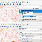


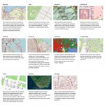

Explore QMS on the map! 🗺️
The QMS catalogue now offers:
🔹 Map-based search and service previews
🔹 Vector Tiles support, including community contributions. Also available through the QGIS plugin and API.
Read more: nextgis.com/blog/explore-qms…

From web map to automated UXO screening reports.
Together with RSK Ordnance Management, we built a custom workflow combining interactive mapping, spatial analysis, and automated PDF report generation using NextGIS Web and NextGIS Toolbox.
Case study: nextgis.com/blog/automated-u…

QuickMapServices for QGIS now supports Vector tiles services. You can now add them at qms.nextgis.com and reuse them in QGIS in one click


NextGIS QuickMapServices 1.4 for QGIS has been released!
You can now mark any service as a favourite and access it easily at any time by switching between the Recently Used and Favourite Services lists.

@nextgis has been selected as one of the Global Top 100 Geospatial Companies of 2026! #Geoawesome100
This is a significant milestone for us, and a recognition of the open source approach to geospatial technology.
Thank you to everyone who trusts, supports, and works with us!

We're introducing NextGIS GeoServices, a self-hosted solution for creating, styling, caching, and publishing high-performance raster and vector basemaps.
Watch the practical tutorial: youtu.be/QkKMD0GK2r8
Read the blog post: nextgis.com/blog/nextgis-geo…

ALT NextGIS GeoServices. Self-hosted solution for configuring and publishing basemaps
Join us tomorrow for a webinar on the NextGIS Mobile ecosystem.
We'll demonstrate how organizations can collect, edit, monitor, and synchronize geospatial data directly from the field.
Register for free to get the link:
events.nextgis.com/event/325…

NextGIS turns 15. Thank you for being part of the journey!
To celebrate our 15th anniversary, we're offering 15% off all orders at data.nextgis.com.
Here’s to the next 15 years of open geospatial innovation!

QGIS 4 is out, but <20% of plugins are fully ported.
New security scans + LLM-driven development are reshaping the QGIS plugin ecosystem.
We discuss how to adapt: nextgis.com/blog/qgis-4-plug…

QGIS Open Day this Friday: major updates to QuickMapServices (vector tiles), OSMInfo, QTiles (PMTiles + tools). Join us!
github.com/qgis/QGIS/wiki/QO…


Interested in modelling land cover change? Sign up for our #QGIS #MOLUSCE webinar: Apr 14 2026, 13:00 (UTC+2) events.nextgis.com/event/314…

Almost forgot! Please vote for the first-ever #FOSS4G talk about #QuickMapServices, the #1 plugin for QGIS.
Fun fact: in 2017, a QMS talk was rejected as “nothing new.” In 2026, it may finally become a talk. Innovation moves fast 🚀
Let's go: talks.osgeo.org/foss4g-2026/… 🙏 #nextgis


💥 NEXTGIS CYBER FRIDAY: 50% OFF EVERYTHING!
Geodata and cloud subscriptions at 50% off! Get unlimited Web Maps, data collection, GPS tracking, QGIS integration and processing tools. Access basemaps, buildings, roads, elevation, POIs.
⏰ Dec 1-5 only!
nextgis.com/black-friday-202…
