

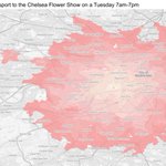





Day 19 of the #30DayMapChallenge: Smell
We mapped public transport travel times to the Chelsea Flower Show using TRACC.
We also tried to make the contour look like a flower. It didn’t quite work, but that’s our excuse for making it pink.
#GIS #TRACC

8
Day 18 of #30DayMapChallenge: NULL
We've had enough of Null Island, so we're off to Shetland!
Using TRACC, we found places over 4 km from the nearest road. Now that's NULL access.
And unlike Null Island, Shetland actually exists!
#GIS #TRACC

1
59
Day 17 of #30DayMapChallenge: Light and Dark
How does streetlighting change accessibility?
Using TRACC, we compared daytime walking access in Manchester with what remains accessible after dark using only lit routes.
Same city, very different results!
#GIS #TRACC

Day 16 of #30DayMapChallenge: Collaborative
We asked Quality Bus attendees what makes somewhere well connected.
Using their priorities and acceptable journey times, we created a custom TRACC connectivity score for Nottingham.
Turns out we don't all agree on accessibility!

3
159
Day 15 of #30DayMapChallenge: Inside Out
An outdoor rainforest, indoors!
We used TRACC to map walking times around the @EdenProject Rainforest Biome in Cornwall.
Although with so much to see, why would you want to rush?
#GIS #TRACC #EdenProject

4
87
Day 14 of #30DayMapChallenge: Borgesian Map
A map so detailed it becomes the territory.
So we made a 1:1 map of Chloe's desk, which was frantically cleaned for the occasion!
Not especially practical, but it might make a decent desk mat.
#GIS #Cartography


3
95
Day 13 of #30DayMapChallenge: Interactions
A LinkedIn comment asked us to map public transport access to Worcestershire Parkway instead of Foregate Street.
So we did!
The results show a very different picture of connectivity across Worcester.
#GIS #TRACC #Accessibility

1
3
61
Day 12 of the #30DayMapChallenge: Power
We compared public transport access to No.10 Downing Street and No.10 North.
Using TRACC, we mapped the catchment for both and found the reach of Downing Street in London is still much greater.
Power shifts, but accessibility matters too

3
84
We're excited to be at the Quality Bus Conference in Nottingham over the next two days. Great seeing how many local authorities are improving buses across Great Britain.


2
76
Day 11 of the #30DayMapChallenge: Sound
@Everton fans hit 131 dB at @EvertonStadium after a stoppage-time winner against Brighton.
So we mapped the 60-minute public transport catchment to the stadium using TRACC.
A big noise needs a big catchment.
#GIS #TRACC #Football

3
59
Day 10 of #30DayMapChallenge: AI
We gave ChatGPT one job: map the UK with major cities, motorways and our logo.
It looks brilliant... until you look closely.
Questionable geography, creative roads and a redesigned Basemap logo!
Our cartographers are safe for now.
#AI #GIS
🤖 Made with AI

2
60
Day 9 of #30DayMapChallenge: Urban/Rural
Does urban mean well connected?
Using TRACC, we found 335 urban MSOAs in England have fewer than 2 bus stops per km².
And having a bus stop doesn't guarantee a useful service!
#GIS #TRACC #PublicTransport

2
169
Day 8 of #30DayMapChallenge: Utopia
We asked the office to describe paradise.
Beaches, pubs, padel courts and somewhere to hide from the kids!
We put it into TRACC, and Margate came out on top.
We're still trying to work out how it beat Cornwall...
#GIS #TRACC

3
76
Day 7 of #30DayMapChallenge: 10 Minute Map
We created an SNLS accessibility map of Worcester in TRACC in under 10 minutes!
Watch the whole process sped up 4x: youtu.be/vVM0ywWD5hE
#SNLS #TRACC

2
105
Day 6 of the #30DayMapChallenge: Vintage 🕰️
Today’s map shows cycling times to antique shops across Manchester, with a more old-fashioned cartographic style for the Vintage theme.
And yes, the journeys were clearly modelled using a penny farthing.

2
62
Day 5 of the #30DayMapChallenge: Sight 👀
How far is your nearest optician?
Using TRACC, we've mapped walking times to opticians across Worcester, revealing which areas have easy access and where journeys take longer.
A different way of looking at accessibility!

5
124
Day 4 of the #30DayMapChallenge: Clusters 🗺️
Our work on the PlusBus website uses dynamic clustering to display bus stops clearly as you zoom in and out.
Here's Guildford's PlusBus zone!
Are you in a PlusBus zone? plusbus.info/

3
105
Day 3 of the #30DayMapChallenge: Polygons
Using TRACC, we've mapped public transport travel times to Worcester Foregate Street Station on a Tuesday morning
The contours show which areas can reach the station within 5–30 minutes, highlighting accessibility varies across the city

3
145
Day 2 of #30DayMapChallenge: Lines
Today’s map shows cycle routes to Worcester Foregate Street Station using TRACC.
Each line represents a journey that can be cycled to the station, showing how different parts of the city connect by bike.

2
104
Day 1 of #30DayMapChallenge: Points
How long does it take to reach Worcester Foregate Street by public transport?
Using TRACC, we've mapped journey times from postcode locations across Worcester on a Tuesday morning (7–9am).
Distance doesn't always equal accessibility!

4
134